Starting From
21,273
18,499.00
Starting From
21,274
18,499.00

Starting From
21,274
18,499.00
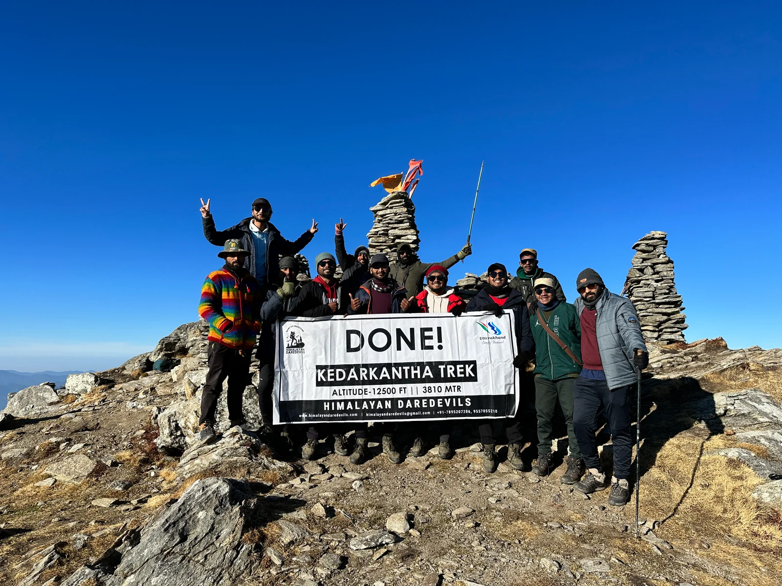
Kedartal Trek (463+ Reviews)
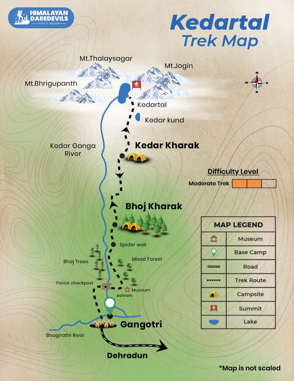
Round Trail. The trek starts and ends at Gangotri
Dehradun Railway Station
Jolly Grant Airport
Gangotri
May, June / September, October
Gangotri to Gangotri
Veg
Camping/ Hotel
Uttarakhand
6 Days
Moderate
15600 Ft
37 Km
Kedartal Trek Overview
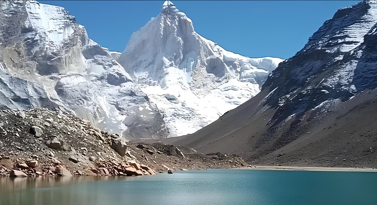
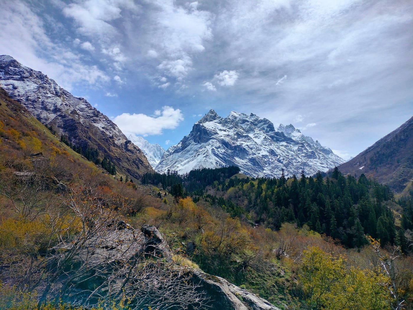
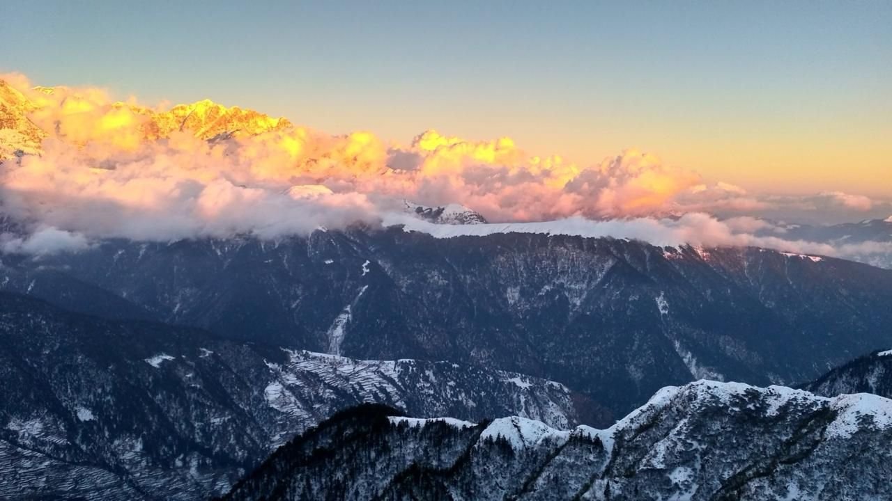
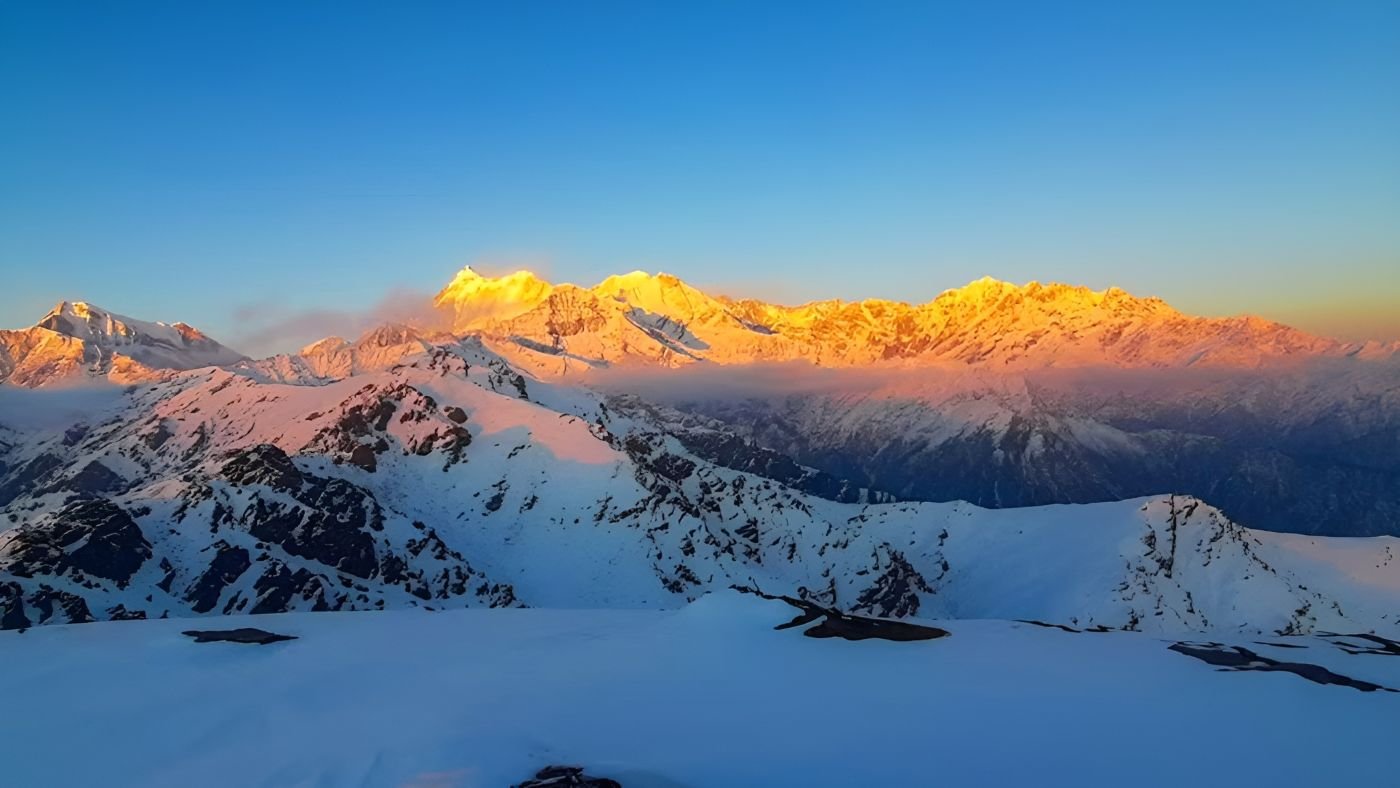
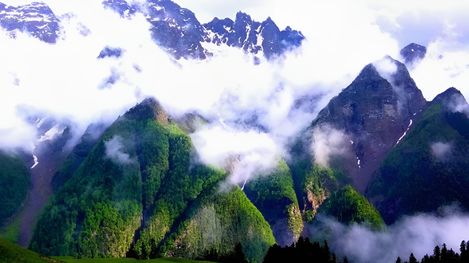
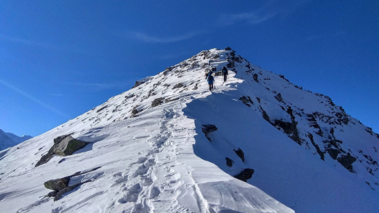
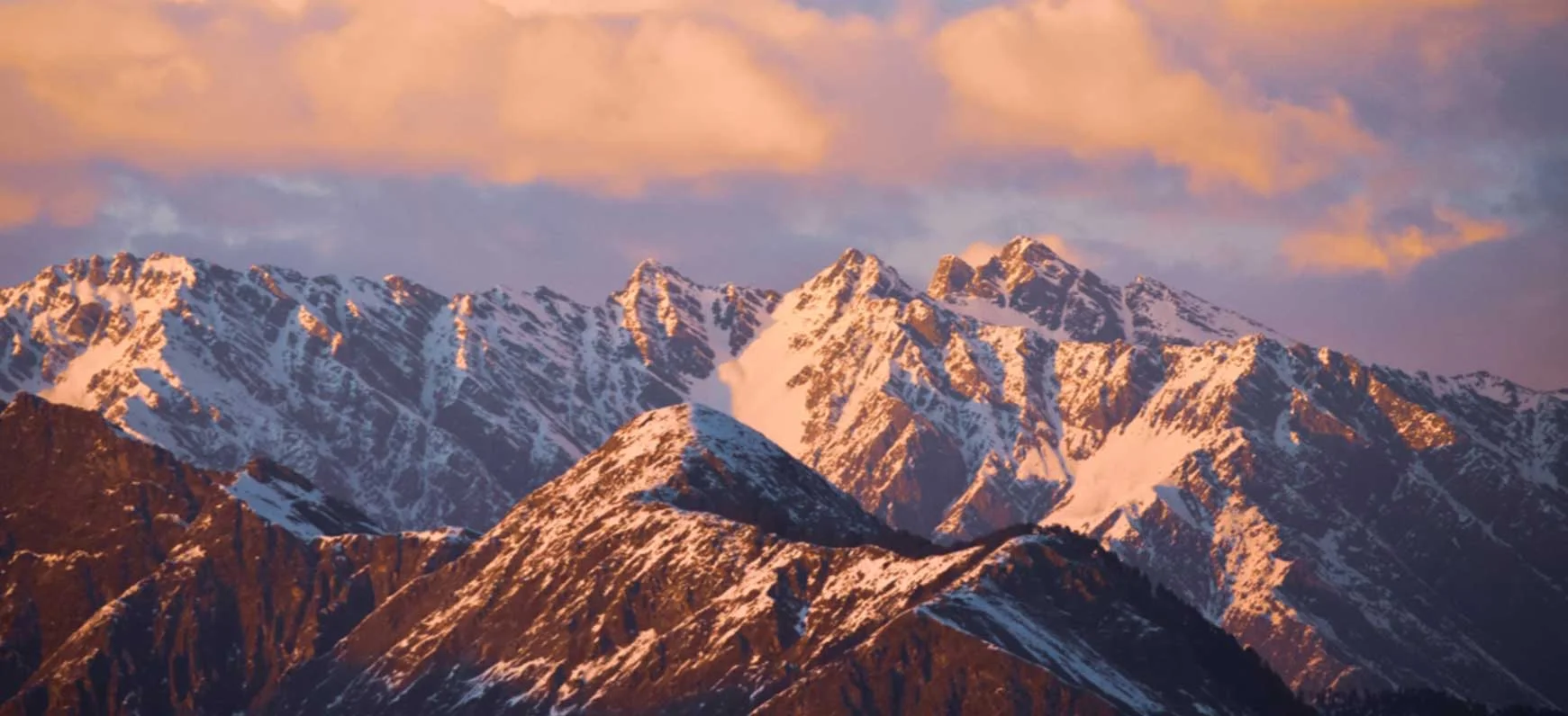
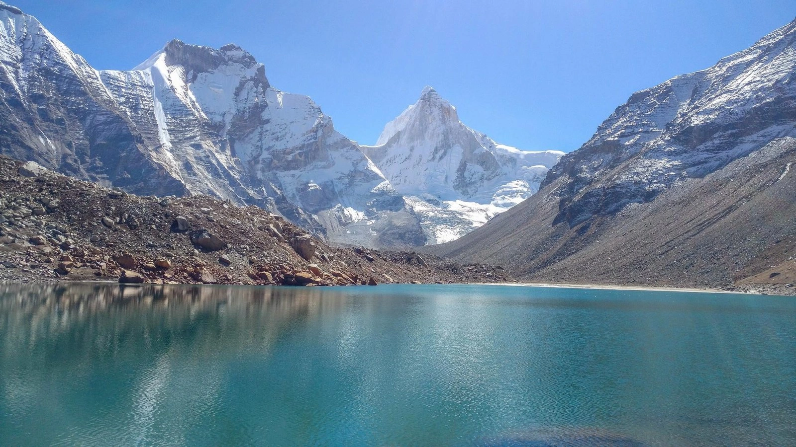
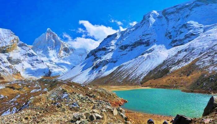
The Kedartal Trek is one of the most challenging and rewarding high-altitude treks in the Uttarakhand Garhwal Himalayas. Known for its rugged terrain and dramatic mountain landscapes, this trek leads to the breathtaking Kedartal Lake, a pristine glacial lake located at an altitude of approximately 4,912 meters (16,116 feet). Surrounded by towering Himalayan peaks such as Thalay Sagar, Bhrigupanth, and Manda Parvat, Kedartal offers a raw and untouched trekking experience for adventure enthusiasts. Often referred to as the “Lake of the Gods”, Kedartal holds deep spiritual significance and is closely associated with Lord Shiva. The trek showcases an ever-changing landscape, ranging from dense forests and alpine terrain to rocky moraines, high-altitude meadows, and snow-covered mountains. With its demanding trail and spectacular scenery, Kedartal is widely regarded as the best Kedartal trek for experienced trekkers seeking a true Himalayan challenge. Starting Point: Gangotri and the Route Ahead The Kedartal trek route begins from the sacred town of Gangotri, one of the four revered Char Dham pilgrimage sites in Uttarakhand. Gangotri is also known as the gateway to the Gaumukh Glacier, the source of the holy River Ganges, adding cultural and spiritual depth to this high-altitude adventure. From Gangotri, the trail gradually ascends towards Bhoj Kharak, the first campsite on the trek. The journey continues through steep and rugged sections, leading to camps such as Kedar Kharak, before finally reaching Kedartal Lake. Covering a total Kedartal trek distance of approximately 37 km, this route demands good physical fitness, stamina, and prior trekking preparation. As the trail gains altitude, trekkers are rewarded with dramatic Himalayan views and an ever-evolving landscape at every stage. But such beauty doesn’t come easy – it demands preparation and respect for the mountain environment. The Kedartal Trek difficulty level is considered high, mainly due to its steep elevation gain and rugged terrain. One of the biggest challenges is altitude sickness, making acclimatization a vital part of the journey. Trekkers are advised to take rest days at strategic points along the route to adapt to the thin air. Along with high altitude there are many other challenges that one faces while on the trek: The Risk: At high altitude, oxygen levels drop, increasing the chance of Acute Mountain Sickness (AMS). Symptoms include headache, nausea, fatigue, and shortness of breath. How to Prepare & Stay Safe: Acclimatize properly: Spend a full day in Gangotri (3,048 m) before the trek. The Risk: Trails through glacial moraines, loose rocks, and narrow ledges can cause ankle twists, slips, and falls. How to Prepare & Stay Safe: Train on uneven surfaces (hikes, stair climbs, rock gardens) to improve balance. The Risk: Continuous ascents can be physically draining, especially in low-oxygen zones, leading to fatigue or cramps. How to Prepare & Stay Safe: Build cardiovascular endurance through brisk walking, running, cycling, or stair workouts. The Risk: Slippery ice patches or snowfields can lead to falls, twisted ankles, or hypothermia. How to Prepare & Stay Safe: Start early in the morning when snow is firm and less slippery. The Risk: Sudden snow, rain, or wind can lower visibility and temperature drastically, increasing the risk of exposure and disorientation. How to Prepare & Stay Safe: Always carry rain gear, a windproof outer shell, and extra warm layers in your daypack. The Risk: No phone signal, medical help, or evacuation support beyond Gangotri. In case of injury or illness, help could be hours or days away. How to Prepare & Stay Safe: Trek with a certified guide and group — never go solo on Kedartal. The Risk: At high altitudes, streams may freeze or dry up. Campsites are basic with no infrastructure. How to Prepare & Stay Safe: Carry a sturdy water bottle and water purification tablets or filter. 1. May to June (Pre-Monsoon Season) 2. September to October (Post-Monsoon Season) Periods to Avoid 3. July to August (Monsoon Season) 4. November to April (Winter Season)The Kedartal Trek is known for its constantly changing terrain, making it one of the most visually diverse high-altitude treks in Uttarakhand. From dense Himalayan forests to rocky ridgelines, moraine fields, and glacial zones, the trail offers a new landscape at every stage. These dramatic transitions not only enhance the trekking experience but also test a trekker’s endurance, balance, and mental strength.
Below is a detailed look at the different terrain types encountered on the Kedartal Trek route.
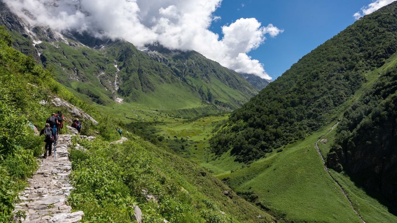
Forested Trails: Gangotri to Bhoj Kharak
From: Gangotri (3,048 m)
To: Bhoj Kharak (3,780 m)
The trek begins with a scenic walk through dense Himalayan forests dominated by oak, deodar, and rhododendron trees. This stretch offers a refreshing start to the journey, with rich biodiversity, birdlife, and occasional sightings of mountain wildlife.
During the spring season, the forest comes alive with vibrant red and pink rhododendron blooms, creating a striking contrast against the lush green canopy. This peaceful forest trail serves as a gentle introduction before the challenging terrain of the Kedartal Trek begins to unfold.
Rocky Trails and Steep Climbs: Bhoj Kharak to Kedar Kharak
From: Bhoj Kharak
To: Kedar Kharak (4,270 m)
As the trek ascends beyond the treeline, the landscape changes dramatically. Forests thin out and give way to rocky trails, steep ascents, and exposed ridgelines. This section is physically demanding and requires careful footing, endurance, and proper trekking gear.
From these rocky slopes, trekkers are rewarded with breathtaking views of deep green valleys below and snow-capped Himalayan peaks rising in the distance. While this section tests stamina, the raw mountain scenery makes every step worthwhile.
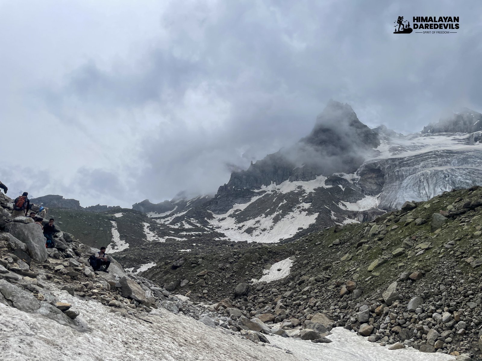
Moraine Fields and Alpine Boulders: Approaching Kedar Kharak
From: Midway between Bhoj Kharak and Kedar Kharak
To: Just before Kedar Kharak campsiteChallenges on The Kedartal Trek
High Altitude (up to 4,750 m)
Ascend gradually: Follow the standard itinerary and avoid rushing to higher camps.
Stay hydrated: Drink at least 3–4 liters of water daily.
Take Diamox (after consulting a doctor) starting a day before the trek.
Monitor symptoms and inform your guide immediately if AMS signs appear.Rugged and Unstable Terrain
Wear high-ankle trekking boots with a strong grip and good toe protection.
Use trekking poles for better stability and reduced knee strain.
Step carefully, especially when crossing scree or wet boulders.Steep Climbs and Long Ascents
Do strength training for legs, back, and core (squats, lunges, planks).
Pace yourself during the trek — “slow and steady” is the key.
Take short breathing breaks, stay hydrated, and eat energy-rich snacks.Ice and Snow Crossings
Carry microspikes or crampons for traction on ice.
Use a sturdy trekking pole for balance and to check snow depth.
Wear waterproof gaiters and insulated boots to prevent cold or wet feet.Rapid Weather Changes
Keep important items (clothes, electronics) in dry bags or ziplock pouches.
Be mentally prepared to halt the trek or return in bad weather — safety over summit.
Check weather forecasts (in Gangotri) and follow your guide’s advice closely.Remote and Isolated Location
Carry a satellite phone or GPS beacon if possible (some guides may have one).
Have a basic knowledge of wilderness first aid.
Let family/friends know your itinerary and return date beforehand.Limited Water and Campsites
Always fill water whenever a clean source is available.
Bring ready-to-eat meals, high-calorie snacks, and a personal stove (optional) if self-supported.
Be ready to camp in basic conditions: carry a warm sleeping bag, insulated mat, and layered clothing.Best Time to Visit Kedartal
Why it’s ideal: This is one of the best windows for the Kedartal trek. As the snow begins to melt, the trail becomes accessible, and the alpine landscape comes alive.
Weather: Days are clear and bright; nights are cold but manageable.
Scenery: Snow still caps the higher peaks; rhododendrons bloom in lower altitudes.
Trek conditions: Trail is mostly stable, though some snow patches may remain at higher elevations.
Why it’s ideal: After the monsoon clears, the air is crisp, and the views are at their most dramatic.
Weather: Clear skies, low humidity, and less crowded trails.
Scenery: Forests begin to show autumn colors; the lake and surrounding peaks offer crystal-clear reflections.
Trek conditions: Trails are dry and safe, with minimal risk of landslides or rain interruptions.
Why to avoid: The region experiences heavy rainfall, which makes the trails slippery and dangerous.
Hazards: Frequent landslides, cloud cover, poor visibility, and leech-infested lower forests.
Access: Roads to Gangotri are prone to closures due to flooding or slides.
Why to avoid: The trail to Kedartal becomes inaccessible due to heavy snowfall and sub-zero temperatures.
Conditions: The lake is completely frozen; deep snow covers most of the path.
Trek status: The route is officially closed and not recommended for trekkers during this time.
Itinerary
Start from Dehradun early in the morning to drive down to Gangotri which takes approximately 8-10 hours, while crossing Rishikesh on your way.
Drive along the Ganga in Uttarkashi amidst the plains of the Himalayas and enjoy the scenic beauty.
End your day by checking into your hotel, offering your prayers at the Gangotri Temple, and sleeping for the night.
SHORT ITINERARY:
DETAILED ITINERARY:
On Day 1 it is advisable to set out from Dehradun for Gangotri which is approximately 8-10 hours by road. Start very early in the morning from Dehradun, and move towards Rishikesh which is well-known for Laxman Jhoola and is known for its religious importance. Then after a short break in Rishikesh for some refreshments or some local sightseeing, proceed further on a picturesque route along the course of the river Ganges through beautiful locales like Uttarkashi.
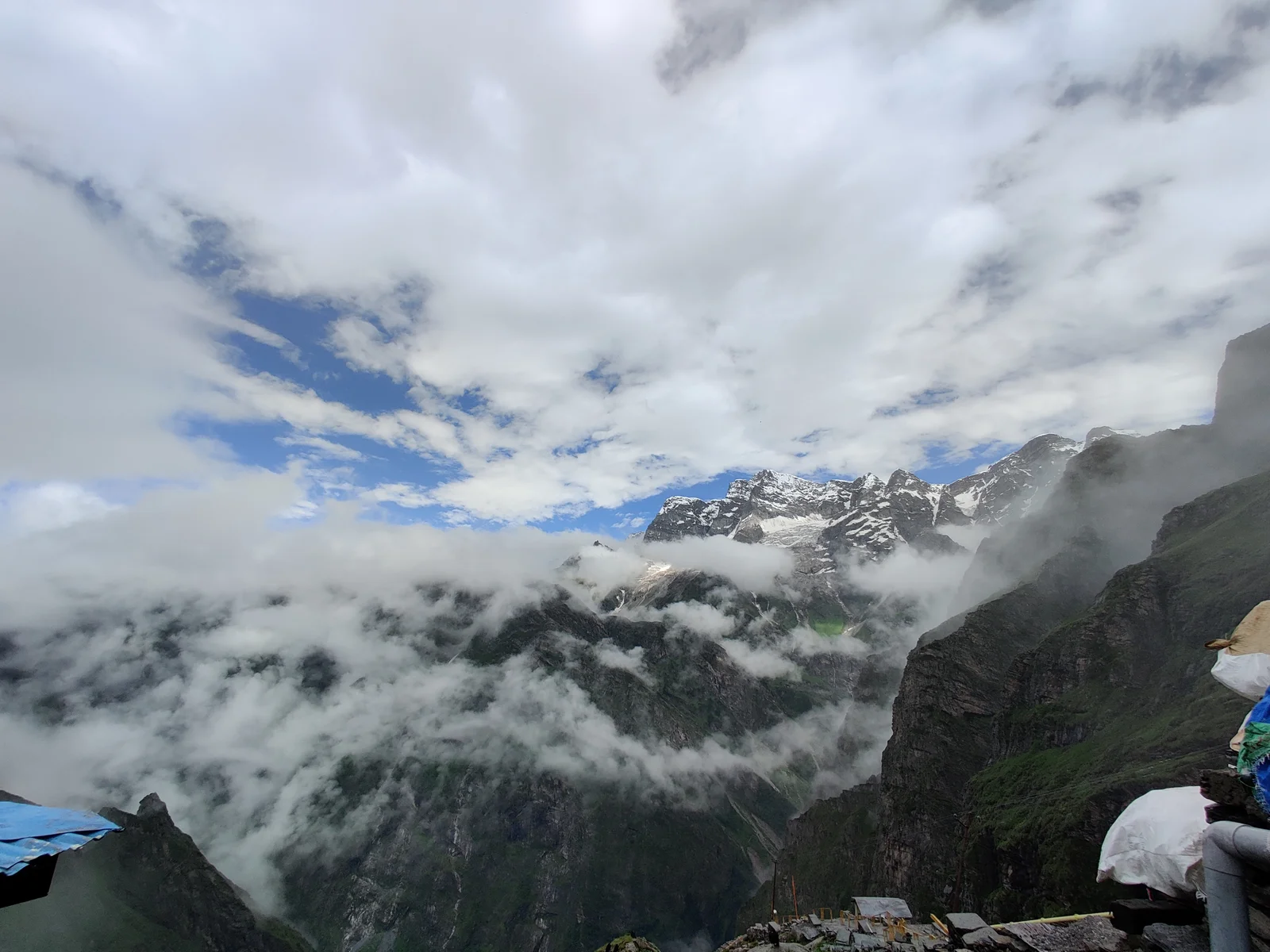
There are stunning views of the Ganges, the green valleys, and the towering ranges of the Garhwal Himalaya from the hills. Near Gangotri, you will also see a different terrain with thick forests.
Check into your hotel to freshen up and hit the town for some local sightseeing as well. You may wish to pay your respects at the Gangotri Temple, devoted to Goddess Ganga, and soak up the serenity and spirituality in the air before embarking on a trek early next morning. This night will be spent in Gangotri, to rest and get to the required altitude before the Kedartal trek starts.
Trek from Gangotri accompanied by the sounds of the Ganga and the fresh air of the mountains.
Transfer across the Bhagirathi River using the Bhairav Ghati Bridge, with GMVN Lodge as a point of reference.
Wander across ashrams and ascend through peaceful oak, rhododendron, and pine woods reaching later on stunning views from the top.
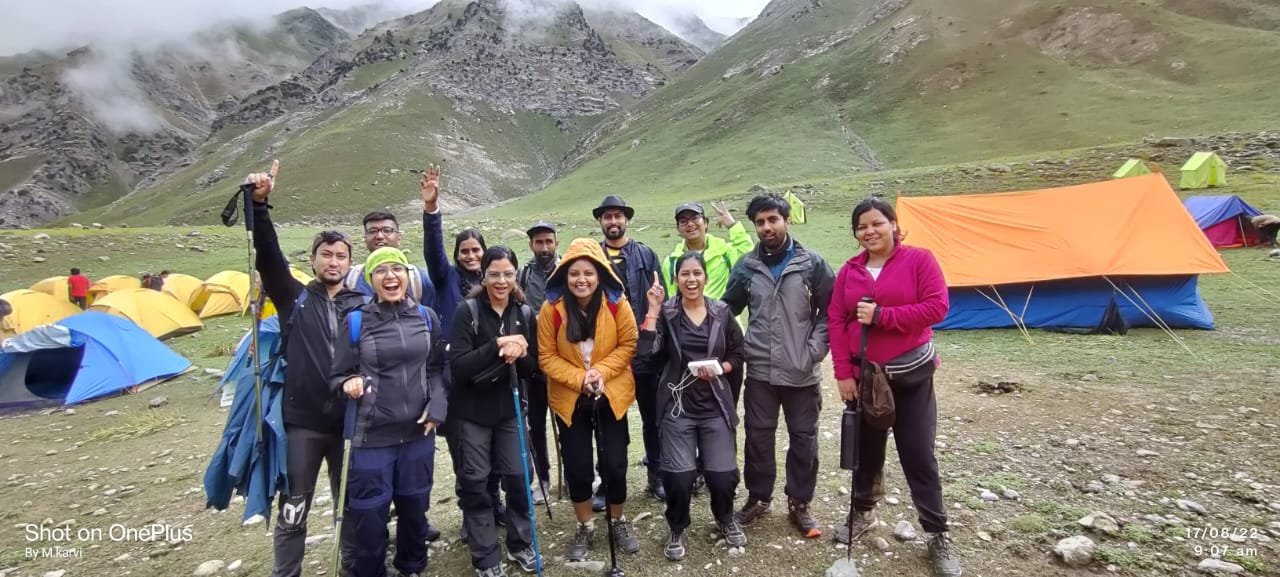
Arrive at Bhoj Kharak (9,500 ft) around the afternoon; establish a tent and adjust yourself for the night.
SHORT ITINERARY:
DETAILED ITINERARY:
As we roll out of our sleeping bags on the first morning of the Kedartal trek, the sounds of the ever-flowing Ganga River and the delightful strong mountain air welcomes us. For today is the day when we start our journey, with our first leg taking us from Gangotri to Bhoj Kharak, the base for our tent for the night. It can be complimented as the journey starts with an advance by crossing the Bhagirathi River through the Bhairav Ghati Bridge. Before we trace the trail further, you will see the landmark of the GMVN lodge to the right. Steadily as we progress, the devotees of yesteryears and quiet ashrams to which they now belong, enhancing the spiritual significance of the walk, can be seen along the pathways.
The path continues to rise as we continue our journey into the more elevated parts of the Himalayas. After covering about 200 meters, we bend to the right which is up along the side of yet another ashram. Then we have a wooded area which is much more inclined than the previous. The very well-defined track passes through picturesque oaks, rhododendrons, and pine forests providing great views and chances of spotting some animals. The difficulty of the upward movement increases as we trek on but the sight of the Head of Bhoj Kharak, 9500 feet above sea level, is indeed encouraging. In the late afternoon, we advance to our campsite and prepare for night's rest as well as for climate adjustment.
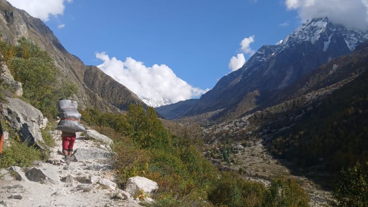
The hike from Bhoj Kharak to Kedar Kharak shouldn’t trouble you much as it has a gentle slope with some slightly pronounced ascents.
The prominent landscape consists of pine forests which eventually vanish to grasslands with Bhrigupanth Peak in the background.
Have a relaxed stroll and observe the higher-order wild life like Bharal, Goral, and Himalayan black bears.
Kedar Kharak marks the end of this trek as the place is at 14240 ft with stony slopes and a stream passing by between which is rather fascinating.
SHORT ITINERARY:
DETAILED ITINERARY:
The trek from Bhoj Kharak to Kedar Kharak is quite easy compared to the previous day’s ascent. There are a couple of unpleasant sections but overall, the terrains have moderate slopes that move in escalated up and down directions. Kedar Kharak, at an elevation of 14,240 ft, is 4 km away, and it takes roughly five hours.
As soon as you step outside the camp tent at the Bhoj Kharak campsite, it is an uphill climb in elevation. After a 1-kilometer leg of the trek passing through the Bhoj forests, the route goes above the tree line and into meadows- splendid for pictures as the towering Bhrigupanth peak peaks from behind the thick clouds.
The following 2 kilometers are enjoyed as a peaceful walk since steep ascents are now fewer. It is in this segment that high-altitude wildlife like Bharal (blue sheep), Goral, Himalayan black bear, and several birds may be spotted.
With increase in height, it gets more and more colder. You will have to be careful as sometimes, frost may appear on the surfaces of stones in the streams. Crossing about two more water sources, you finally reach Kedar Kharak.
Surrounded by a few rocks and a running river, the campsite is located on a large dry plain. The rocky route along which the stream rises is the path for the Day 4 Trek.
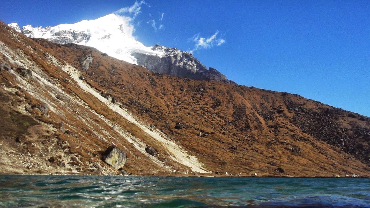
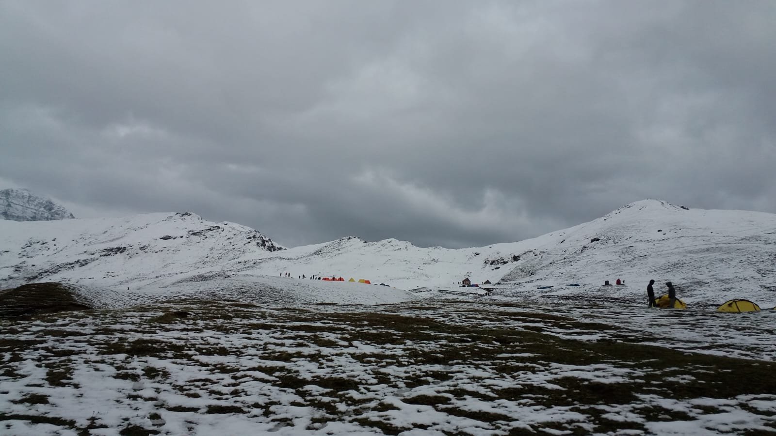
Wake up early to begin the hardest section of the trek, where you’ll head to the emerald lake at 16,116 ft.
The way is rough, dry, and steep with a chance of snow or rain due to erratic conditions. Though there are cairns to indicate the way, the chances of losing the way are very high due to the rock-studded and twisted nature of the land.
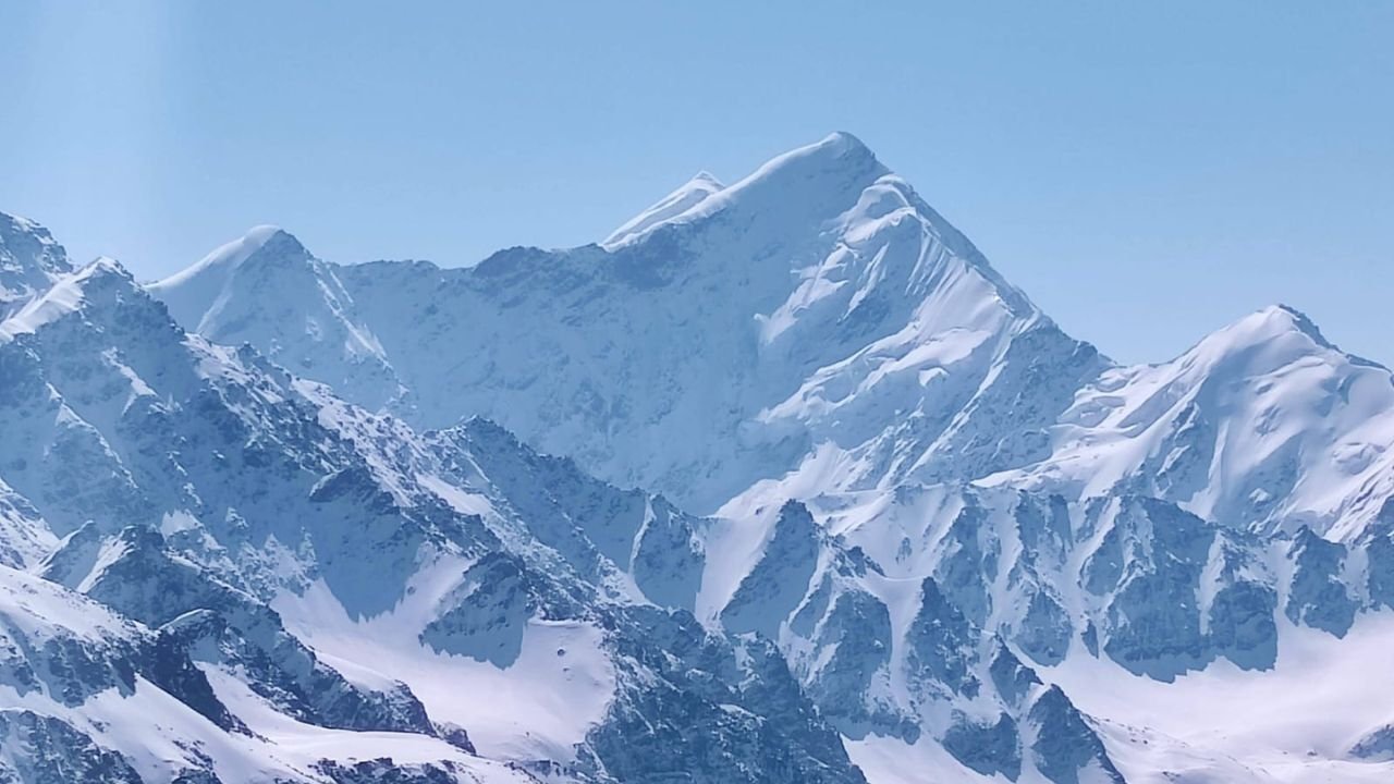
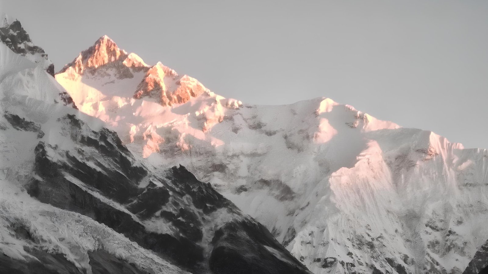
After 5 to 6 hours, reach the lake with the sight of Thalaysagar Peak looming over.
SHORT ITINERARY:
DETAILED ITINERARY:
Mostly on this day, the trekkers’ enthusiasm is highest as they look forward to reaching the emerald lake which offsets the tiredness endured during the earlier days’ treks.
Why you need to start early on this stretch is because it is the most difficult of all. It is also noted that ‘Tal’ which is at an elevation of 16,116 ft about 5 km from Kedar Kharak is a climb over barren, rocky, and treeless mountains.
Though quite inexplicably dry, the landscape can be breathtaking. With more uphill movements than downhill ones, the geography makes it physically demanding because one must consider the unpredictable weather conditions. There is a high chance of snowfall as well as rain during this period. This terrain is perhaps best characterized as a convoluted mass of rocks, with one or two minor streams far away so that we are forced to bring enough water with us. Some words are required explanation, ‘terrain’.
One can easily go around in circles and not notice that the route is wrong after some time. Therefore, many cairns, which are piles of stones, have been erected along the way to the Tal to indicate where the right places are. Be careful where you put your feet as there are numerous loose rocks on the way. After 5-6 hours of trekking and reaching a distance of half a kilometer from the lake, you can view the towering Thalaysagar
You may now begin making your way back to Gangotri and start by taking breakfast as you start returning happily along your footsteps.
The return trek may take less time since the majority of the trail is on a decline.
Take care of loose stones while you are coming down.
Relish the last view of the beautiful views as you come back to Gangotri.
SHORT ITINERARY:
DETAILED ITINERARY:
Set out for the descent to Gangotri, immediately after breakfast. Retrace your steps with joy as you get a last glimpse of the locations. Since most of the trail is descending, it should take less time to reach. Take note of the loose rocks along the trail.
The distance from Gangotri to Dehradun is 242 km and it takes close to 8hrs. The journey time may vary depending on road conditions and the breaks taken.
View the towering plains of the Himalayan mountain, valleys, and the Ganga while making your return from the mountains.
Pass through the sacred city of Rishikesh with temples & ghats and a spiritual touch on the banks of the Ganges.
The trip ends with a gentle descent through the last setting of foothills into the calm region of Dehradun.
SHORT ITINERARY:
DETAILED ITINERARY:
The trip from Gangotri to Dehradun is approximately 242 km, which takes about 8 hours, but can be slightly less or longer, depending on the condition of the roads and how many stops are made to rest along the way. The journey from Gangotri heavily features views of the Himalayas, vegetation-dense valleys, and the Ganges. As you get off the peaks, the road starts to dip and leave the mountains before reaching the town of Uttarkashi, where you can stop for a short rest if necessary.
As you move ahead in your journey there are signs of development as the mountains dissipate and floodplains, fields, forests, and other forms of wildlife start to emerge. Furthermore, the journey takes you through Rishikesh, a holy town along the banks of the river Ganges, adorned with temples and ghats. From Rishikesh onwards, the stretch till Dehradun has downhill slopes passing through the foothills. Once you reach Dehradun, the tranquil surroundings of the city are ready to welcome you, signaling the end of the captivating trip.
Kedartal Trek Map
Inclusions
Exclusions
1. Meals while on trek (Veg).
2. All necessary entry fees and permits.
3. Accommodation:- Guest house, Home stay, camping during Trek.
4. Mountaineering qualified & professional trek Leader, guide, cook and Support staff.
5. First aid medical kits, stretcher and oxygen cylinder.
6.Trek equipment: Sleeping bag, mattress, tent (twin sharing), kitchen & dinning tent, toilet tent, utensils and crampon (if required)
7. Staff Insurance.
8. Porters/mules to carry central equipment
1. Any kind of personal expenses.
2. Food during the transit.
3. Mules or porter to carry personal luggage.
4.Transport (Non Ac)
5. Insurance.
6. Any kind of emergency evacuation charges
7. 5% GST
8.Any expense incurred or loss cost by reasons beyond our control such as bad weather, natural calamities (landslides, floods), flight delays/rescheduling/ cancellations, any accidents/medical evacuations, riots/strikes/war/pandemics etc.
9. Anything not specifically mentioned under the head
What to carry
Shoes and backpack
- Trekking shoes with ankle support
- Backpack with rain cover
Warm Layers and Clothes
- Warm layers (PaddedJacket)
- 3 layers if you're trekking in spring, summer and monsoon (1 woollen sweater, 1 fleece, 1 padded jacket)
- 4 layers if you're trekking in autumn (1 woollen sweater, 2 fleece, 1 padded jacket)
- 5 layers if you're trekking in winter (1 pair of thermals, 1 woollen sweater, 2 fleece, 1 padded jacket) - 3 Collared T-shirts (Wear one, carry two)
- 2 quick-dry trek pants (Wear one, carry one)
Accessories
- Sunglasses
- Sun cap with flaps
- Waterproof gloves
- Balaclava
- Woollen socks (3 pairs)
- Headlamp
- Trekking pole
- Rain jacket + pants / poncho
Toiletries:
- Sunscreen
- Moisturiser
- Light towel
- Lip balm or vaseline
- Toilet paper
- Toothbrush
- Toothpaste
- Reusable plastic covers (for used clothes)
Compulsory Documents to Carry
These files must be submitted to the Forest Department before your trek. With none of these, you will not be permitted to trek. Original and photocopy of government photo identity card. Carry Ids like Aadhaar, voter id, etc.
How to reach
Reaching Rishikesh (Nearest Major Transit Hub)
By Train
From Delhi
Nanda Devi Express (12205): Departs Hazrat Nizamuddin at 11:50 PM, arrives at Haridwar by 4:00 AM. Continue to Rishikesh by taxi or bus (approx. 45–60 minutes).
Dehradun Shatabdi (12017): Departs New Delhi at 6:45 AM, reaches Haridwar by 11:30 AM.
From Chandigarh
Chandigarh–Haridwar Intercity Express (14609): Departs Chandigarh at 4:10 PM, arrives at Haridwar around 9:30 PM. Continue to Rishikesh by taxi or bus.
By Bus
From Delhi (ISBT Kashmere Gate)
Overnight Volvo and deluxe buses to Rishikesh/Haridwar run daily. Travel time: 6–8 hours.
Buses typically drop passengers at Rishikesh ISBT or Tapovan. Local taxis and autos available for short transfers.
From Chandigarh
Direct buses to Rishikesh take approximately 5–7 hours. Shared taxis are also an option.
Rishikesh to Gangotri (Trek Base)
Distance: Approx. 270 km
Travel Time: 10–12 hours
Altitude: 3,048 meters
Transport Options
Private Taxi: Most convenient and time-efficient option. Can be arranged directly in Rishikesh or online.
Shared Taxis: Available early morning from Rishikesh or Haridwar to Uttarkashi. From there, change to Gangotri.
State/GMOU Buses: Operate in the morning to Uttarkashi. Fewer direct buses to Gangotri — may require an overnight halt in Uttarkashi.
Route Overview
Rishikesh → Chamba → Uttarkashi → Harsil → Gangotri
This scenic mountain drive follows the Bhagirathi River and passes through lush valleys, steep ridges, and Himalayan foothills. Road conditions are winding but generally well-maintained. After Uttarkashi, mobile networks became limited.
Additional Notes
Best Time to Travel
The road to Gangotri is open from late April to early November.
Ideal months for travel: May–June and September–October (post-monsoon).
Acclimatization
Gangotri is at over 3,000 meters. It is strongly recommended to rest here for at least 1 day before starting the trek to Kedartal.
Trek Start
The Kedartal Trek begins from Gangotri. A forest check post marks the start of the trail. Permits are issued here and can be arranged in advance or on-site.
Fitness and preparation guide for Kedartal Trek
Trekking to Kedartal is a physically demanding high-altitude journey. Proper physical preparation ensures not only safety but also enhances your experience. Below is a comprehensive guide outlining each key fitness area, why it matters, and how to train for it.
1. Cardiovascular Endurance
What it is:
The ability of your heart and lungs to support sustained activity.
Why it’s important:
The Kedartal trek involves long walking hours (6–8 hours/day), steep ascents, and low-oxygen environments. Strong cardiovascular health helps manage breathlessness and fatigue.
How to train:
Jogging, cycling, stair climbing, or brisk walking — 4 to 5 days a week.
Start with 30–45 minutes per session, gradually increase to 1 hour or more.
Include interval training (e.g., alternate 1 minute fast, 2 minutes slow) to boost stamina.
2. Leg Strength
What it is:
The power and endurance of your thighs, calves, and glutes.
Why it’s important:
You’ll face continuous elevation gain, especially between Bhoj Kharak and Kedar Kharak, requiring strong and stable legs.
How to train:
Exercises: squats, lunges, step-ups, calf raises.
Practice hiking or walking stairs with a loaded backpack.
Aim for 3–4 strength sessions per week.
3. Core Strength
What it is:
Strength in the muscles around your abdomen, lower back, and pelvis.
Why it’s important:
A strong core improves posture, reduces back strain, and helps maintain balance on uneven terrain.
How to train:
Exercises: planks, Russian twists, mountain climbers, bird dogs.
Train your core 3–4 times a week for 15–20 minutes per session.
Include movement-based core work (not just static holds).
4. Shoulder and Back Strength
What it is:
The strength of your upper body to support pack weight.
Why it’s important:
You’ll be carrying 10–12 kg in a backpack for several hours daily.
How to train:
Exercises: push-ups, dumbbell rows, shoulder presses, lat pull-downs.
Practice wearing your actual trekking pack during walks or stairs.
Focus on posture and pack fit to avoid strain.
5. Flexibility and Joint Mobility
What it is:
Your range of motion in muscles and joints.
Why it’s important:
Good flexibility reduces the risk of cramps, injuries, and stiffness, especially on steep or rocky descents.
How to train:
Stretch daily (10–15 minutes) focusing on hamstrings, quads, hips, calves, and shoulders.
Incorporate yoga or mobility drills 2–3 times per week.
Stretch before and after hikes or strength workouts.
6. Balance and Coordination
What it is:
The ability to control your body on uneven surfaces.
Why it’s important:
The terrain near Kedartal includes moraine fields, ice, and boulders where good balance prevents injury.
How to train:
Single-leg exercises like one-leg stands and single-leg squats.
Practice walking on uneven trails or with a loaded pack.
Use trekking poles during training to simulate actual conditions.
7. Breathing Efficiency and High-Altitude Adaptation
What it is:
Your body's ability to use oxygen efficiently at altitude.
Why it’s important:
Kedartal is at 4,750 m where oxygen is about 60% of sea level. Efficient breathing helps reduce fatigue and risk of altitude sickness.
How to train:
Practice deep breathing or pranayama daily.
Train nasal breathing during cardio sessions.
Incorporate breath-hold or CO2-tolerance drills under supervision.
8. Mental Toughness and Discipline
What it is:
The resilience to endure discomfort, fatigue, and unpredictability.
Why it’s important:
Weather, physical strain, and isolation demand a strong mindset and the ability to keep moving even when it's hard.
How to train:
Simulate tough conditions with long hikes, early workouts, or cold exposure.
Stick to a consistent routine — discipline builds mental strength.
Reflect on goals and visualize success to maintain motivation.
9. Recovery and Rest
What it is:
Allowing your body to repair and get stronger after training.
Why it’s important:
Recovery prevents overtraining, reduces injury risk, and keeps you energized for continued progress.
How to train for it:
Prioritize 7–9 hours of sleep each night.
Take at least one rest day per week.
Use foam rolling, light yoga, or mobility work for active recovery.
Weekly Training Strategy (Optional Framework)
Weeks 1–2
Build base fitness: start cardio, introduce strength and core workouts.
Weeks 3–4
Increase hike duration, intensity, and simulate treks with a backpack.
Weeks 5–6
Include back-to-back training days, higher elevation hikes, and cold weather practice.
FAQ
The best time for the Kedartal trek is between May to June and September and October. During these months the views will be clear and the temperature will be moderate. To enjoy Kedartal trek it will be advisable to trek during these months. On the other hand winter and monsoon should be avoided because of the difficult situations such as landslides and slippery terrains.
The Kedartal is considered as a difficult trek. The trek is full of rugged terrain and trekkers should be prepared to trek on steep ascends, rocky paths and the high altitude. Therefore, it is advisable to be experienced while doing Kedartal trek.
The total time taken to complete the Kedartal trek is 6 days. The trek is generally done in 5-6 stages, with each day covering different distances and elevations. You will witness the beauty of the Himalayas.
While prior trekking experience is suggested it is not deemed compulsory provided you are fit enough and are willing to strive hard. But because of its high altitude and rugged terrain, it is better suited for experienced trekkers to handle.
Accommodations are on a basic level during the ttkedartal trek. Trekkers campapeose, there are no permanent lodges or guest houses along the route, apart from some of the mountain camps. Some of these camps include Bhoj Kharak, Kedar Kharak and a site that is situated around the Kedartal Lake.
The activity not only focuses on cardio as it builds stamina and improves the core but also significantly boosts the endurance level of those participating in the trek. It is also important to acclimatize to it slowly. When preparing for the trek practice at higher altitudes and ensure your gear is appropriate for the cold and harsh conditions.
The clothes generally worn for the Kedartal Trek include warm clothes (such as down jackets), boots suitable for walking, warm sleeping bags, a tent (if the guide does not provide one), walking sticks, sufficient aid kit, sunscreen, flashlight, and enough food supplies and drinking water. It is also necessary to carry enough warm clothes as protection against cold weather experienced at the higher altitudes.
Kedartal Trek is generally safe considering that the undertaking is made by trained and experienced trekkers. However, as with any high altitude region, there are dangers which trekkers should prepare themselves for such as altitude sickness, weather changes, and the difficult terrain. Consider trekking with a porter or a guide for that extra layer of security, especially if you’re new to the trek/altitude. Always adhere to safety, drink plenty of fluids, and adjust to the cooler environment.
Kedartal Trek can be done alone, however it is not encouraged to do so especially for people that have never attempted a trek before. The Kedartal Trek can be difficult because of its challenging terrains, high altitude and remote location so its better to go with a guide or a group. You should have experience in climbing high-altitude mountains along with good navigation skills and be self-reliant along with having measures in place in case of an emergency if you attempt it all alone. That’s why many people choose to become a part of organized trekking groups in order to make the process easier and safer.
Cancellation policy
Life is unpredictable and we understand sometimes you have to cancel or change your trip dates and it is our endeavour to make it as easy possible for you. However, please understand we plan everything including guide fees, permits, accommodation and ration in advance. Therefore any cancellation means inconvenience and certain losses to the people involved in various stages of programme. Keeping that in mind, our cancellation charges are as below-
Cancellation prior to 30 days from start of the event: Get monetary refund with 15% of cancellation charges on trek fee.
Cancellation between 30 days and 15 days to the start of event: 50% on trek fee is non refundable and the remaining 50 % will be given as cash voucher which is valid for 1 year.
Cancellation less than 15 days to the start of event: No refund.
Please note cancellation will be only accepted by email.
Booking amount is non refundable
Note: The Himalayan Daredevils reserves the right to cancel a programme before departure in the event of logistical problems arriving due to natural calamities, strikes, wars on any other circumstances that makes the event inadvisable. In this case, 50% on trek fee is non refundable and the remaining 50 % will be given as cash voucher which is valid for 1 year.
Itinerary changes & trip delays:
We plan itineraries based on the information at the time of planning and in rare circumstances, there are subject to change. In the event that the itinerary is changes or delayed due to unforeseen circumstances such as bad weather conditions, transportation delays, government intervention, landslides etc. We will always aim to give you the best experience possible. However The Himalayan Daredevils are not be held responsible for the cost of delay or changes.
Why Choose Us
Our Best Performance
50,000+
Trekkers
PAN India Treks
250+
Treks
Professional
and Experienced Staff
Best
Grade Equipment
Well Organised
Trek Itineraries
Related Blogs
Read and get more about our treks
Top 5 Best Treks in Uttarakhand - Himalayan Daredevils
The Beauty of Sar Pass Trek - A Visual Journey Through the Himalayas
Explore the beauty of Har Ki Dun Trek - A complete Guide
Gaumukh Tapovan Trek: Detailed Itinerary, Trekking Essentials & Best Time to Visit
Ali Bedni Bugyal: Detailed Itinerary, Trekking Essentials & Best Time to Visit
Goechala Trek: Detailed Itinerary, Trekking Essentials & Best Time to Visit
Complete Guide to the Brahmatal Trek Route and Itinerary
Valley of Flowers Trek- What It Gives and What It Doesn’t
Best Time for Ali Bedni Bugyal Trek: Season-Wise Guide for Trekkers

Top 10 treks to do with friends
Top 10 Reasons to Choose Buran Ghati Trek This Season
Which is Better: Pangarchulla Peak Trek or Kuari Pass Trek?
Top 10 Best Trekking Companies for Kedarkantha Trek (Safety, Price & Reviews)
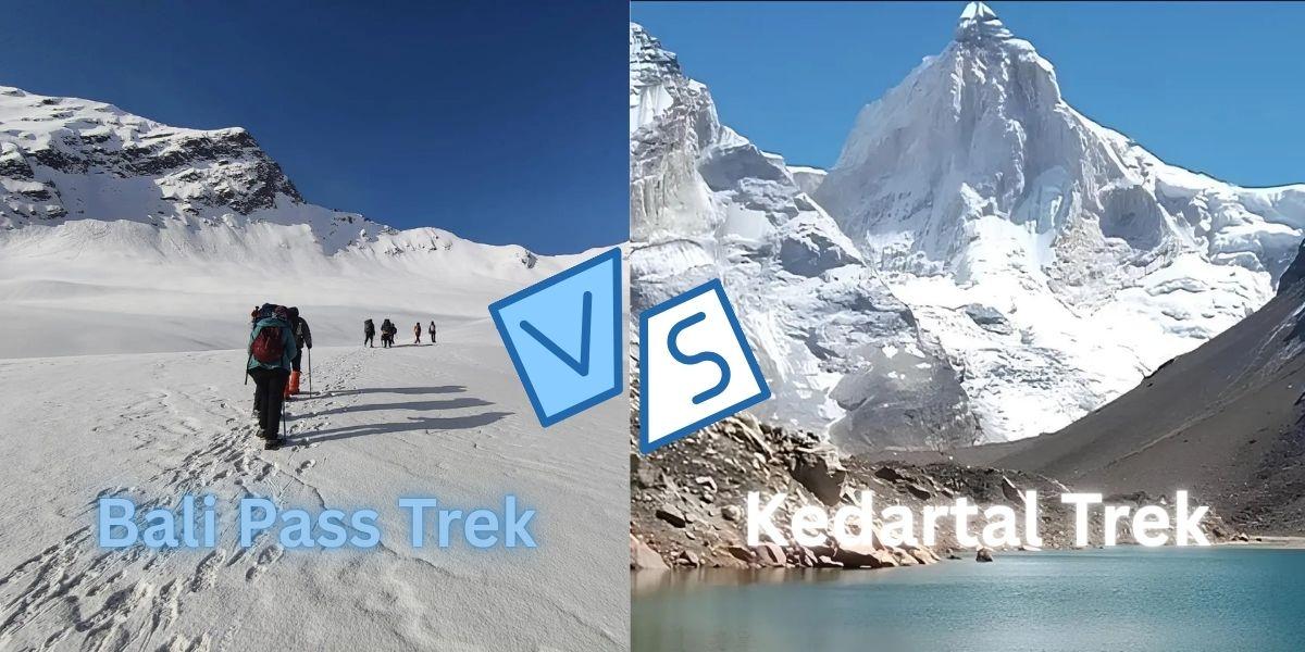
Bali Pass Trek vs Kedartal Trek: Which High-Altitude Himalayan Trek Should You Choose?

Kedartal Trek Best Time: Month-by-Month Weather, Snow Conditions & Difficulty Explained
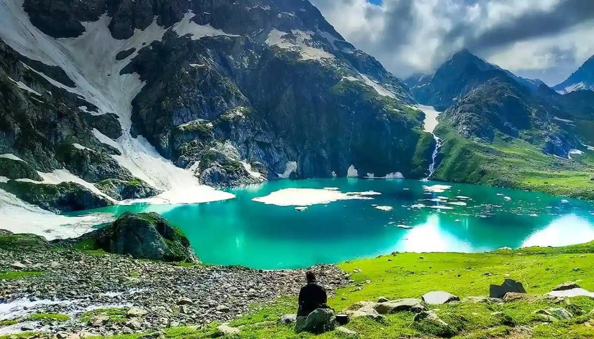
Kedartal Trek vs Kashmir Great Lakes Trek: Difficulty, Altitude, Best Time & Scenery Compared

Kedartal Trek Distance and Route Guide
How to Prevent Altitude Sickness on Kedartal Trek
What Makes Kedartal A Difficult Trek

Kedartal Trek Best Time (Month-by-Month Guide)
Best Time to Visit Tungnath Trek (Complete Seasonal Guide 2026)
Affiliated and Recognised by


Download Our Apps