Starting From
27,025
23,500.00

Starting From
27,025
23,500.00


Starting From
27,025
23,500.00
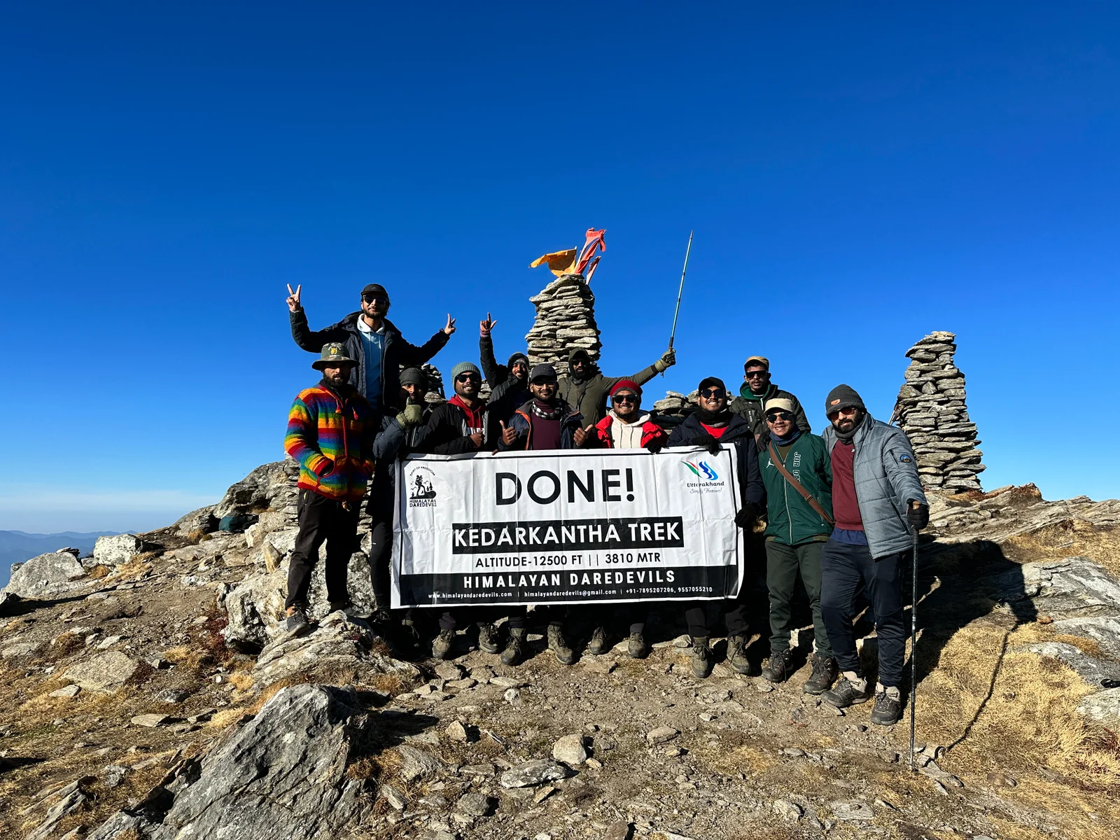
Roopkund Trek (357+ Reviews)
Circle trail | Camping in various locations, starting and ending at the same point.
Kathgodam
Jolly grant Airport - Dehradoon
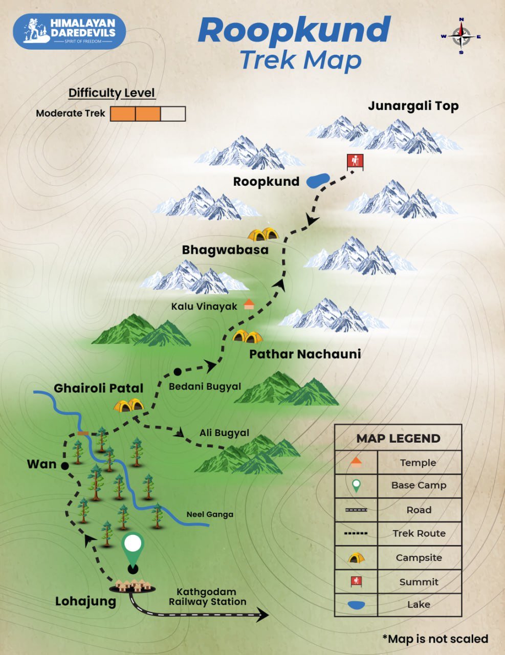
Lohajung
May | June | September | October
Lohajung to Lohajung
Veg
Guesthouse / Camping tent
Uttarakhand
8 Days
Moderate
16000 Ft
54 Km
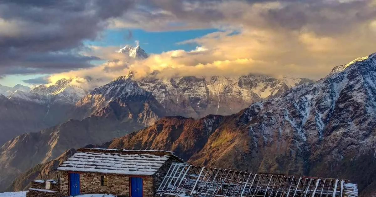
Roopkund Lake Trek Overview
The Roopkund Trek is a very adventurous and famous trekking trail situated in the state of Uttarakhand, India, often described as Roopkund trek – trek the Himalayas experience. It is known for its enigmatic ‘Skeleton Lake’, situated in vast snow-capped mountain flanks. In Roopkund, however, one will see plenty of human and animal bone remains strewn around the lake which are believed to be scavenged from pilgrims of ancient times, who probably died in an unfortunate event. This enhances the already interesting aspect of the trek which makes it an adventure for lovers of nature and history alike.

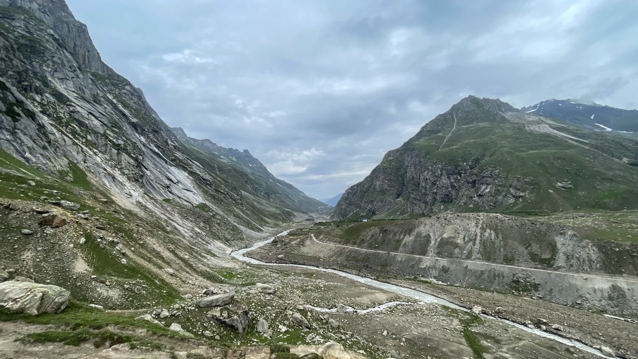
Roopkund Trekking Route
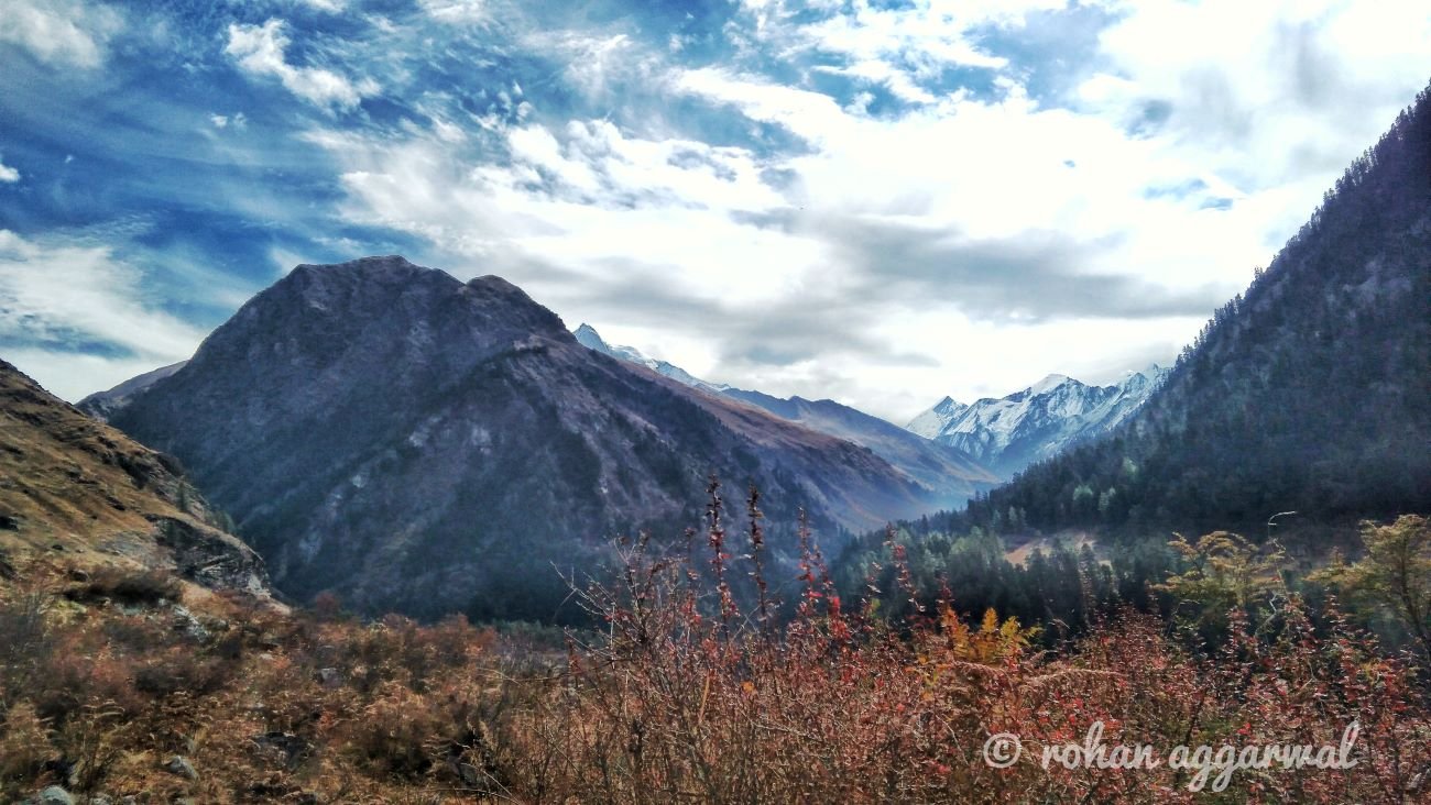
The Roopkund Lake Trek starts from the base village Lohajung, which forms the classic Roopkund trek route and can be reached by road from Kathgodam or Nainital. From there, the trekker will proceed to the lake through beautiful villages and thick oak and rhododendron forests. The whole trek is moderate in difficulty but a gradual climb is prolonged by a few steep steps, which is well planned in professionally curated Roopkund trekking packages. The route meanders through isolated villages, providing opportunities to get in touch with natives and taste their local life rich in culture and exotic rural Himalayan features.
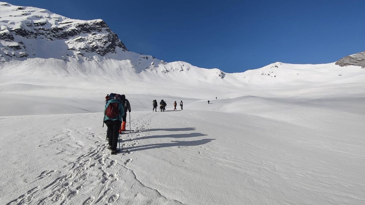
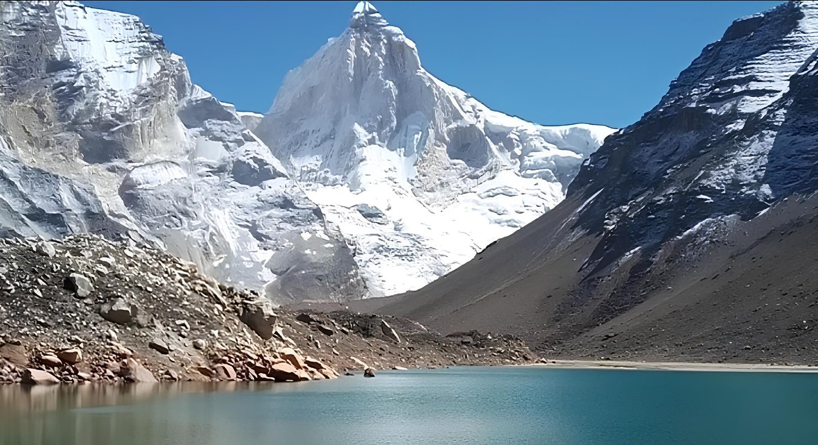
At the beginning of the Roopkund lake trek as the elevation increases, the scene changes to glacial features, pastures, and eventually, the beautiful Himalayas. Fielding Trishul to the north, Nanda Ghunti to the east, and an endless row of snow-capped peaks to the west, the trek unveils scenic mountain landscapes. The high-altitude geography also introduces trekkers to various species of the Himalayas flora and fauna, adding sweetness to the journey. Positioned at 16,000 feet (4,876 meters) above sea level, this clearly defines the Roopkund trek height, with the lake encaged by spectacular towering peaks that look awe-inspiring when covered in snow.
Scenic Views of Roopkund Trek
But the trek to Roopkund Trek not only tests the physical endurance of travelers but also rewards those who wish to venture into the wild, unexplored regions of the Indian Himalayas. The trek encounters several highlights, for example, Bedni Bugyal’s meadows as well as Junargali Pass which provides one of the best panoramic views of the entire trek’s mountains. Present almost in every season, an element of surprise is created when snow garnishes the already eye-catching sunken village and lake Roopkund.
Ideal Time For Roopkund Trek
The ideal time for undertaking the Roopkund Trek is either in the pre-monsoon season of May to June or in the post-monsoon period of September to October as the weather is then considered to be the most suitable. Since the trekking altitude scale is considerable, experienced trekkers will find the trek to be the most suitable for them. This region has the best of adventure, the past, and mother nature rolled into one, making it ideal for curated Roopkund trekking packages., a perfect trek for those who crave the maximum physical challenge in one of the most mysterious trekking locations in India.

Key Highlights of The Roopkund Trek
Here are some of the highlights of The Roopkund Trek that makes the trek special
The Mystery Of The Lake
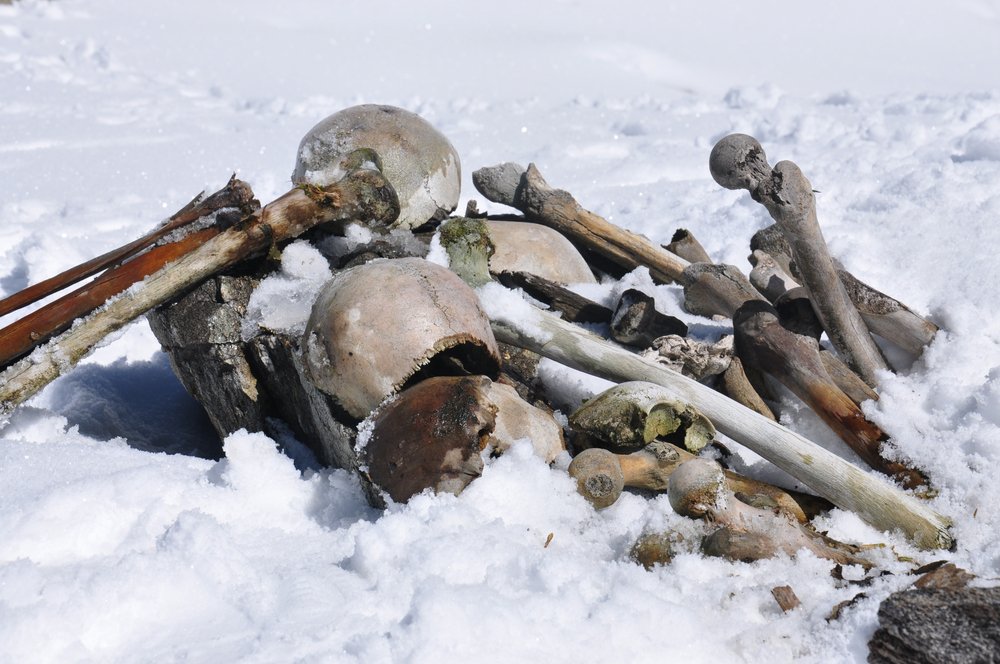
The Roopkund lake is also known as the Skeleton Lake. This beautiful glacial lake takes this name because it is surrounded by hundreds of human skeletons that are known to be very old. Whose skeletons are these? and what are they doing here in this extreme high altitude region? This still remains a mystery.
The local legend tells us about a 9th century king who along with his entourage was going on a pilgrimage to Nanda Devi Shrine. Along the way the King indulged in a lot of disagreeable things that angered the goddess who showered hail storms on the group. It is said that the skeleton lies there and to tell a tale of caution, to never disrespect this sacred land.
In 2019 a team of scientists conducted DNA analysis of the 38 skeletons and found out surprising results. 23 individuals had DNA of Indian origin and dated back to 800 CE, while 14 others had genetic roots linked to the eastern Mediterranean- think Greece-these dated to around 1800 CE. What were these people from the Mediterranean region and elsewhere doing so far away from home? Where were they going?
Altitude
Roopkund is a fascinating place surrounded by ancient mysteries and beautiful mountains but reaching here is no easy task. At a height of 5,020 meters from the sea level, the lake stands higher than most major peaks in Europe or North America. High altitude regions have flora and fauna that are different from the rest of the world. You will get to see wide green meadows of Ali and Bedni Bugyal and see the high mountain peaks of Nanda Ghunti and Trishul
The high altitude also makes the air thin, making breathing difficult and increasing the risk of Altitude Sickness. Ones should ascend gradually and stay hydrated to avoid this.
Adventure and Challenge
The Roopkund trek is one of the most challenging moderate to difficult treks in India. The wild and unforgiving terrain of the high altitude Himalayas pushes you to your physical and mental limits, along with this the unpredictable weather and steep ascents make this trek especially challenging.
The Roopkund Lake trek spans 6 to 9 days where you are required to trek for 6 to 8 hours per day. The lack of basic comforts of a modern life like- no bed, no running water, no heating adds extra difficulty to the experience.
The Roopkund Lake Trek is for the ones who have an appetite for adventure and who want to explore the secrets that this ancient trail holds. Reaching the Lake after trekking through tough terrain and many challenges makes the achievement much sweeter, truly a journey that would stay with you forever.

Where Does The Roopkund Trek Start From?
The Roopkund lake trek starts from a quaint himalayan village called Lohajung, located in the Chamoli district of Uttarakhand. The name ‘Lohajung’ means ‘War with Iron’, the place takes this name from the battle between goddess Parvati and a Demon named Lohasur from the hindu mythology.
Lohajung is well connected by road from Rishikesh and Dehradun and is a basecamp for many other treks like the Brahmatal. At a distance of 210 KM from Dehradun, this marks the starting point of the Roopkund trek distance, and it would take you around 9 to 10 hours to reach here.
What Is The Best Time To Visit The Roopkund Lake Trek ?
The Roopkund lake trek is a high altitude trek that is filled with challenging terrain, because of this there is a small window in which you can visit the lake.
Summers (May to June):
The trail during the early summer months is filled with patches of snow providing a thrilling trekking experience. The later summer months will offer you green meadows bursting with many colored wild alpine flowers. The temperature during daytime ranges from 5°C to -1°C and at night drops down to -3°C to 4°C. This is a good time to visit the lake, but the final snow covered ascent does require proper gear and guidance.
Autumn (September to Mid October)
The trail after the monsoon season is clear as the snow has melted, the sky is clear and the air is crisp. You also get the unobstructed view of the mountain peaks far away. During these months you also get a better view of the lake. The temperature during daytime ranges from 6°C to 1°C and at night from 4°C to -4°C.
Seasons to Avoid
The months of Monsoon (July to August) should be avoided because the heavy rainfall in the region causes landslides and roadblocks. The Winters (November to March) sees heavy snowfall making the region inaccessible.
An Unforgettable Experience
The Roopkund trek is not an ordinary trek, and considering the experience, scenery, and logistics, the Roopkund trek cost offers great value for a journey into a long and distant past filled with unknown mysteries and tales. The trek takes you to the green meadows and the dense pine trees all surrounded by the white snow capped peaks. Yes, the trail is challenging but with challenges comes thrill and adventure which makes the journey an unforgettable event.
Trekking the tough terrain to reach Roopkund requires guidance, and at Himalayan Daredevils, the Roopkund trek price includes expert guides who know these mountains like the back of their hands. who know these mountains like the back of their hands. Our certified trek leaders and local guides ensure that you experience the mountains with safety, care, and authenticity. Whether you are a seasoned or a first time trekker, our well-designed Roopkund trek package ensures your journey is safe, enriching, and memorable.
Tips & Tricks For Roopkund Trek by Himalayan Daredevils Expert Guide

Itinerary
Drive for 9 to 10 hours to reach Lohajung from the Kathgodam railway station
See the beautiful Shivalik hills of the Kumaon Himalayas
Reach Lohajung a village of not more than 15 houses
Rest at Lohajung for the night, if possible trek to the beautiful Ajan Top.
SHORT ITINERARY:
DAY 1: Pickup from Kathgodam Railway Station – Drive to Lohajung Village Distance: 220 KM / Time: 9–10 Hours / Altitude: 7,700 ft (2,347 m)
DETAILED ITINERARY:
From Kathgodam Railway station, our vehicle will pick you up and continue to Lohajung which is about a 9/10 hour drive. Make sure to have your breakfast and lunch while traveling. We will pass through the Kumaon region as well as the valleys of the Shivalik mountain ranges. The road is fascinating as it passes through nice locations with green forests, bends, and views of mountains in the background. It is mostly cold here since we are going up and it is rainy and foggy very often. You will have dinner and spend the night at a hotel or a homestay.
After a brief sight of Tharali, Lohajung has Mt Nanda Ghunti which is usually the first gantry seen as you ascend into the region. Lohajung, which is an amazing valley of Didina, is the main hub of about 12 to 15 villages.
According to villagers, the name is derived from a legend according to which, Goddess Parvati fought a raging demon named Lohasur in this place. One of the villagers runs a small shop where winter jackets, hand gloves, caps, shoes, etc. can be purchased if necessary. This shop is not that reliable since it is recommended that all necessary preparations for the trek are done before arrival.
Most parts of this village will also have a mobile network. If you have a whole day free, a trek to Ajan Top can be undertaken. Occasionally pictured atop a hill, Ajan Top can be an ideal picnic spot. The view here is magnificent because one can see Maiktoli.
After breakfast, begin your trek and reach Wan, a village about an hour away from Lohajung. The beginning of the trek is well paved, witness the stunning Cypress Trees
Next destination is Ranaka Dhar which is 30 to 45 minutes from Wan.
While on the way to Ranaka Dhar the trail splits in two, one of the trails goes to Latu Devta Temple.
Reach Ranaka Dhar and see a birds eye view of Wab, Lohajung and the valley.
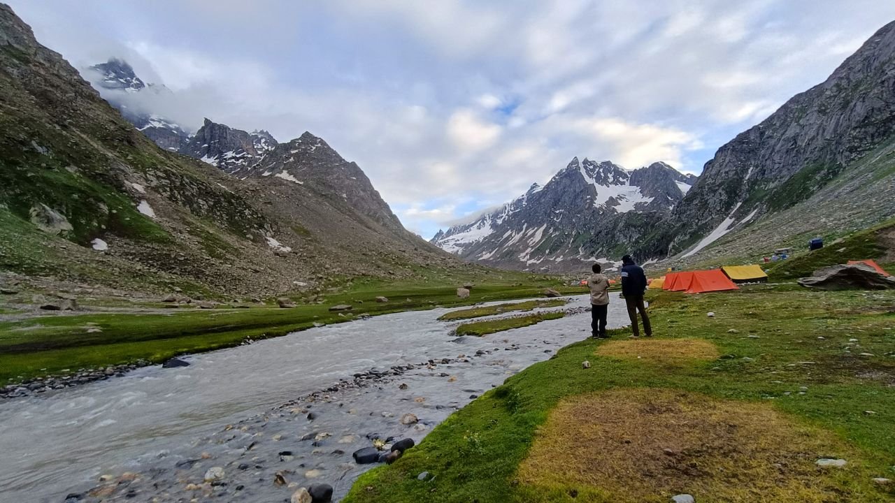
After Ranaka Dhar Relax at Neel Ganga and then continue to reach Gehroli Patal. The Climb to Gehroli Patal is filled with Rhododendron and Oak trees.
Camp for the night at Gehroli Patal.
SHORT ITINERARY:
DAY 2: Trek from Lohajung via Wan to Ghairoli Patal Distance: 9 KM / Time: 5–6 Hours / Altitude: 8,500 ft (2,591 m)
DETAILED ITINERARY:
After your breakfast, your trek begins by moving towards Wan. Start from Wan, a village located at an hour’s drive from Lohajung. It is one of the cemented trails which runs through inhabited houses. After walking forty-five minutes into your trek, a cluster of cypress trees that are many centuries old stands ahead. It's big enough to take 4 people around it! Give it a shot and wrap your arms around the tree, instead.
You will see two trails from here. One follows the ridge straight ahead. The other branches of the Latu Devta temple. Latu Devta, who is mostly worshipped by mountain residents, brings safety to the land. He is invoked by devotees before moving further upcourt at the Nanda Devi Jat Yatra at the temple. Hit the temple bell here for a safe trek and go back to the trail that takes you to the ridge-Ranaka Dhar. It takes 30-45 minutes to climb the distance from Wan to Ranaka Dhar. At such heights, the unbeatable sites of Lohajung, Wan, and the valley should not be missed! It is said that the demon Lohasur was defeated by Goddess Parvati in the place named Ranaka Dhar. This was also the place where their war, in which Lohajung was the starting place, also ended. The word Ranaka Dhar translates to blood that is tempered by battle.
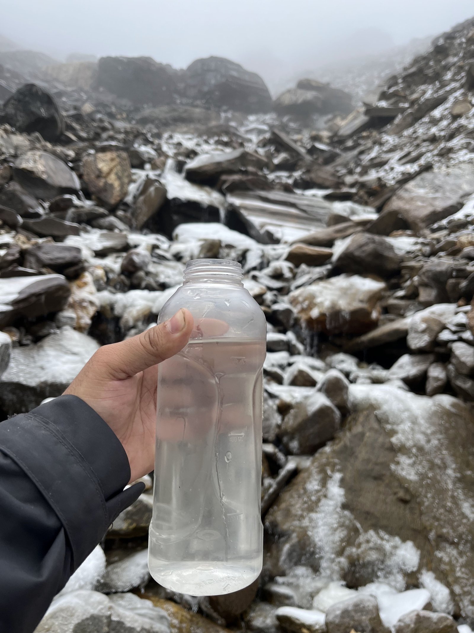
At this point, it’s a few steps downward to reach the Neel Ganga. A break on the bridge built on Neel Ganga is a cool place. The water in this place is clean and cool.
From here, you can reach Neel Ganga. Bridges on Neel Ganga are good places to sit and relax. Trees hang over the river and the water trickles down and tumbles over the rocks in the shade. The waters of this place are rather cool and soothing. This is where the lustrous hill climb towards the first base camp, Gehroli Patal, starts. The route now goes through Oak and Rhododendron and one can hear the sound of dry leaves being crunched under the soles of their trekking shoes. This trek has walnuts, pears, Himalayan roses, and all other forms of flora. Some birds like the flycatcher and the magpies can also be seen. Be careful and vigilant.
Begin the day's trek by walking on a trail covered by Oak and Rhododendron trees.
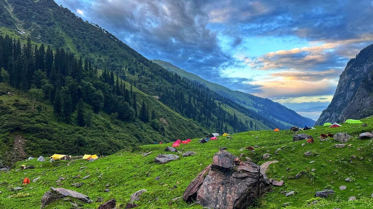
Reach the beautiful Ali Bugyal, the largest meadow in Asia.
See the expansive lush green meadow enjoy and relax for some time
Return back to Ghairoli Patal.
SHORT ITINERARY:
DAY 3: Trek from Ghairoli Patal to Ali Bugyal and back to Ghairoli Patal Distance: 12 KM / Time: 6–7 Hours / Altitude: 11,320 ft (3,448 m)
DETAILED ITINERARY:
The path during this section goes up, through the forest of oak and rhododendron, steeply. And after climbing up for fifteen minutes over stony steps, there is a large flat area. A wide plain known as Ali Bugyal is to the right and in that direction there is a path that goes to the right. The trees begin to recede after about 1 and a half hours of ascent. There is a moment when the oak and the Rhododendrons seem to vanish from view and what lies ahead is an expanse of the fullest green carpet that could be ever offered to one. Welcome to Ali Bugyal. All the fatigue disappears, now enjoy the beautiful view of the rolling meadows of Ali Bugyal.
You are on top of a ridge that extends out in all four directions. There are wide stretches of lush green grass on the mountains. With all your weariness eased, let your eyes soak in the captivating view of the rolling meadows of Ali Bugyal. One is at the ridge which radiates outwards in every direction – vast expanses of green grassland channeled out from the slopes of the mountains. Slow-moving clouds roll in from below, envelope the ridge, and proceed to flow down on either side with all its grace. You see innumerable steeds in peaceful motion feeding themselves on greenery. After exploring Ali Bugyal we will come back to Ghairoli Patal.
Trail to Pathar Nachauni is easy and leisurely
See the beautiful Bedni Bugyal and the majestic mountains that are visible from there.
Camp at Pathar Nachauni for the night.
SHORT ITINERARY:
DAY 4: Trek from Ghairoli Patal to Pathar Nachauni via Bedni Bugyal Distance: 9 KM / Time: 6–7 Hours / Altitude: 12,818 ft (3,906 m)
DETAILED ITINERARY:
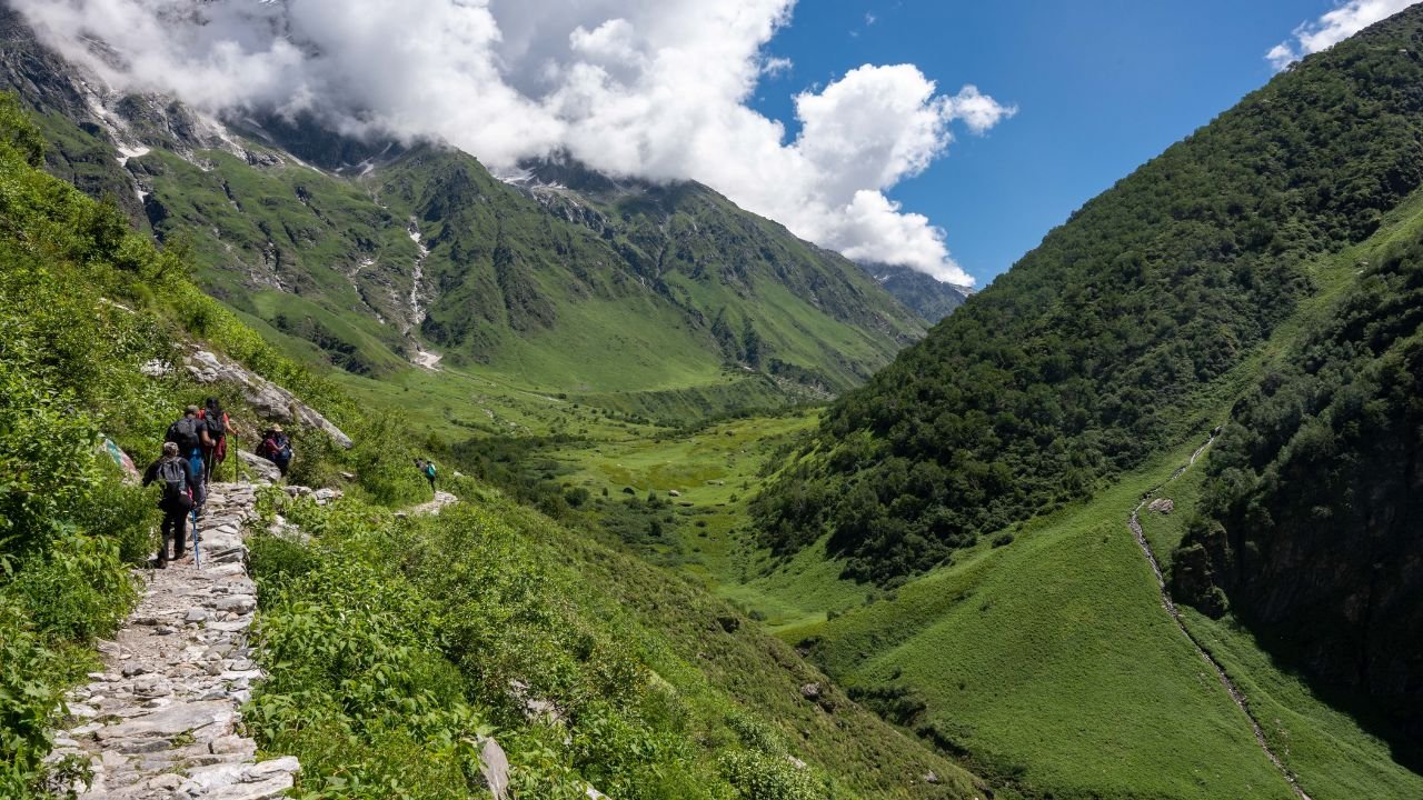
On day 4, we will trek from Ghairoli Patal to Pathar Nachauni through Bedani Bugyal. From the Bedni Bugyal, the trail to Pathar Nachauni departs in a leisurely, easy curve. From Bedni, it can be observed proceeding out of the mountain for almost 3 km before it vanishes into a saddle. As soon as you go beyond the saddle while trekking, you get to see the other side of the ridge. The view is equally breathtaking but different. You also start seeing patches of winter snow on the flanks of the mountain (on the other side) for the first time.
There are two ways one can follow the trail that leads to Pathar Nachauni and further to Bhagwabhasa. It is possible to go back the way you came yesterday until the main trail is left to enter the Bedni campsite zone (5-7 mins backward).
Trek to Bhagwabasa will take 5 to 6 hours, it is said that here the goddess Nanda turned dansers into stone.
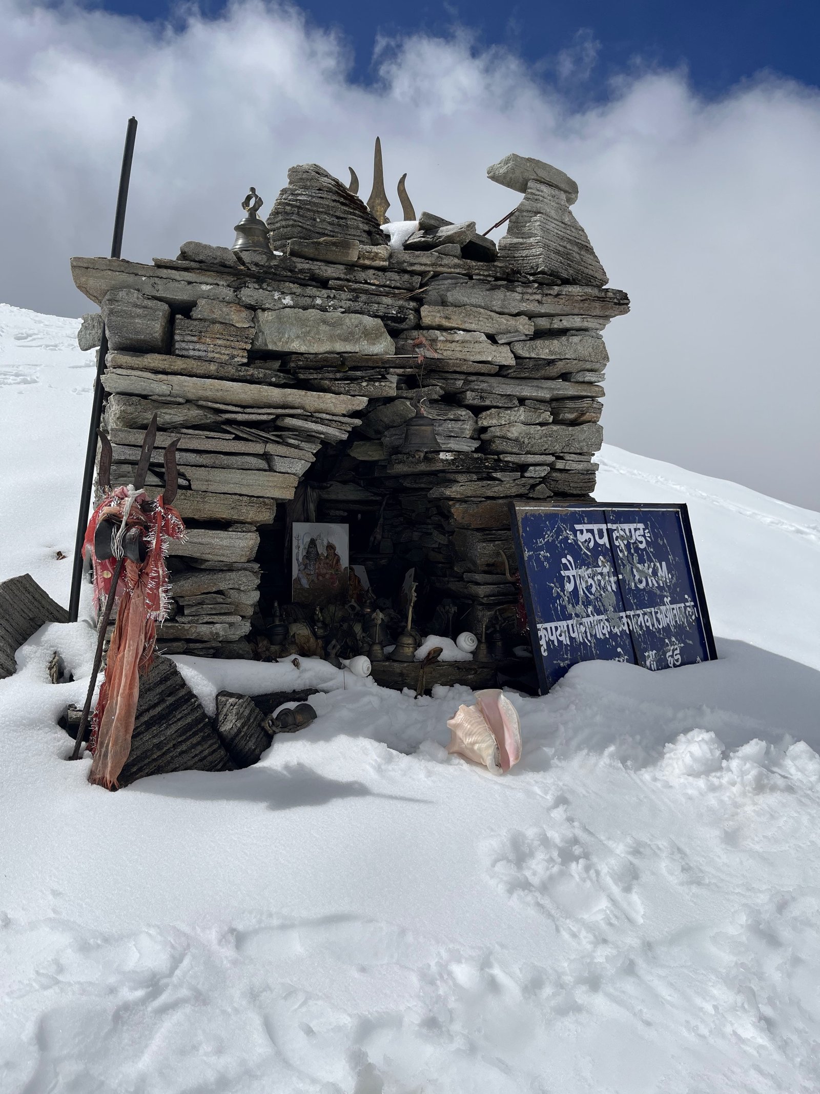
Take a detour to go to Kalu Vinayak Temple, the detour is difficult.
From the temple get a glimpse of Roopkund, and himalayan mountains like Mount Trishul
Camp for the night at Bhagwabasa.
SHORT ITINERARY:
DAY 5: Trek from Pathar Nachauni to Bhagwabasa via Kalu Vinayak Distance: 6 KM / Time: 4–5 Hours / Altitude: 14,117 ft (4,303 m)
DETAILED ITINERARY:
After breakfast, proceed to trek towards Bhagwabasa (14,126 feet) which is a trek of approximately 6 km and will take around 5 to 6 hours to get there. As per the lore surrounding this place, the dancers were cursed by goddess Nanda to be turned into stones. Patthar- stone Nachauni- dancers. Begin the trek in the direction of Bhagwabhasa and the same path will lead you towards Kalu Vinayak temple, But this will require you to trek an additional 2 km at an altitude of 200 ft. This line is difficult again it is not straight and has curves so be careful as one fumble can be the worst thing ever. But in any case, this climb is worth every single effort because once at the top, you will be awe-struck. Yes, at that place, there is room for wind as the height increases, oxygen is less at this level and hence while going up take pauses and water. Kalu Vinayak – The temple has a traditional design and is made of stones but it looks beautiful and unique. In the atmosphere there, you can feel the spirituality. In such high altitude temples, it is a place that is so high that only people who love to discover new things can relate.
Upon arriving at the temple, you will catch a glimpse of Roopkund which is the destination you shall head to on the next day and also an endpoint to your long journey. The view includes the beautiful Mount Trishul on one side and Nandaghunti on the other side to truly captivate the eye.
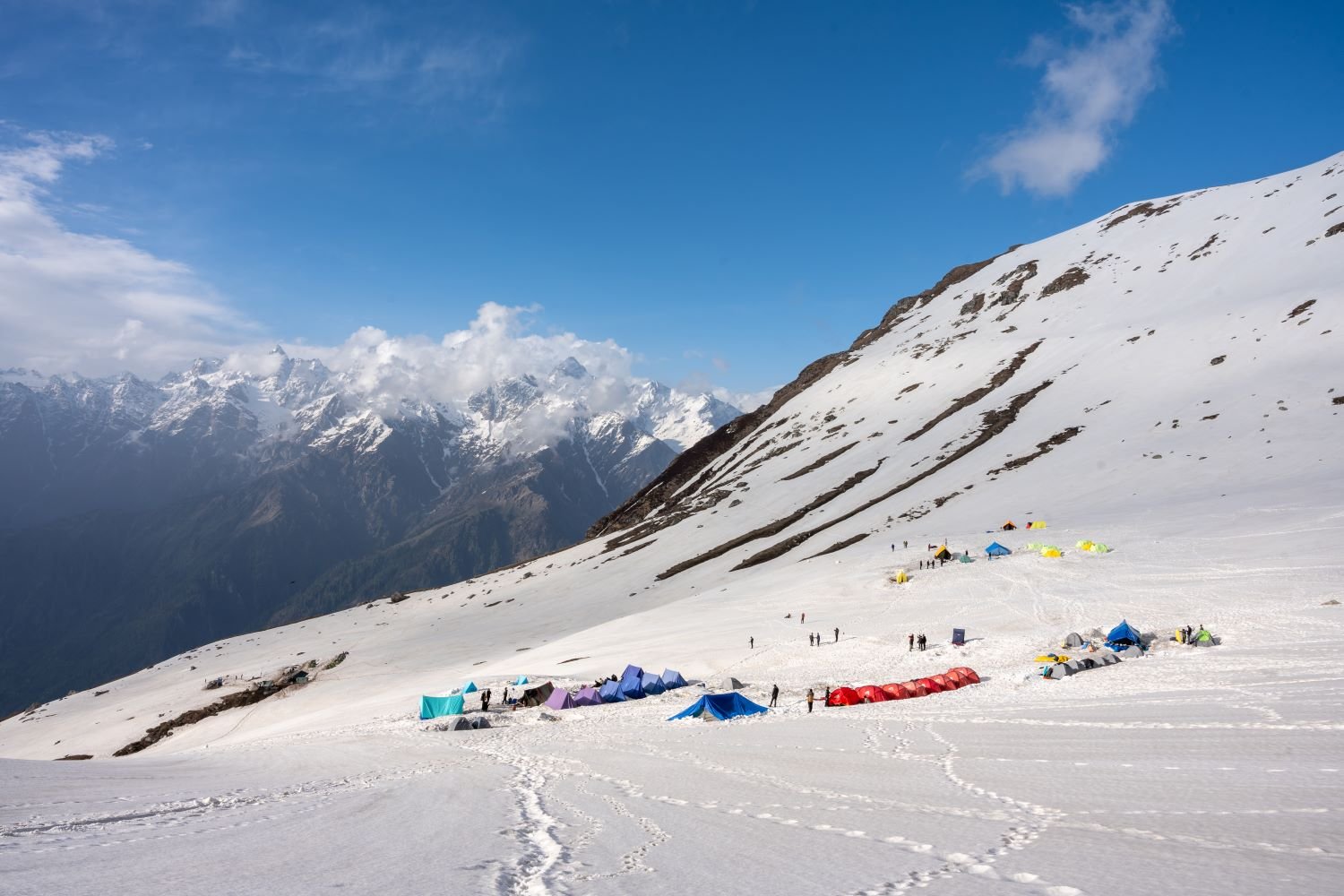
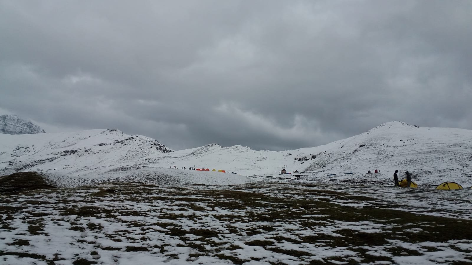
As stated, proceed on the path that will lead you to Bhagwabasa which is 1 km from this point. The path is full of stones and it is pretty difficult to cross it, pause, and move on to locate Bhagwabasa, which is, however, a desolate site during the monsoons there is an abundance of flowering plants in this vicinity. Pitch your tents and enjoy dinner, followed by an overnight stay.
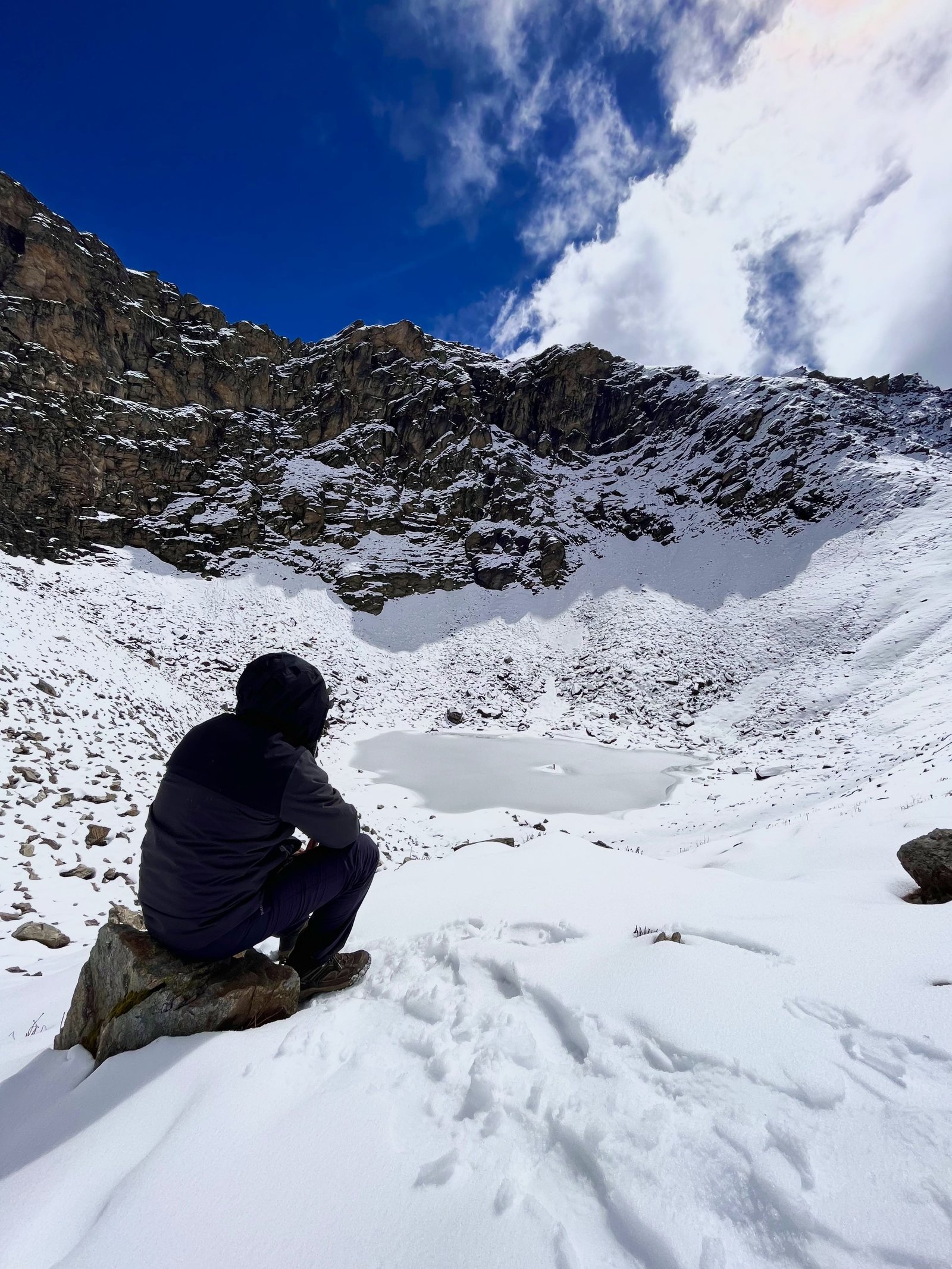
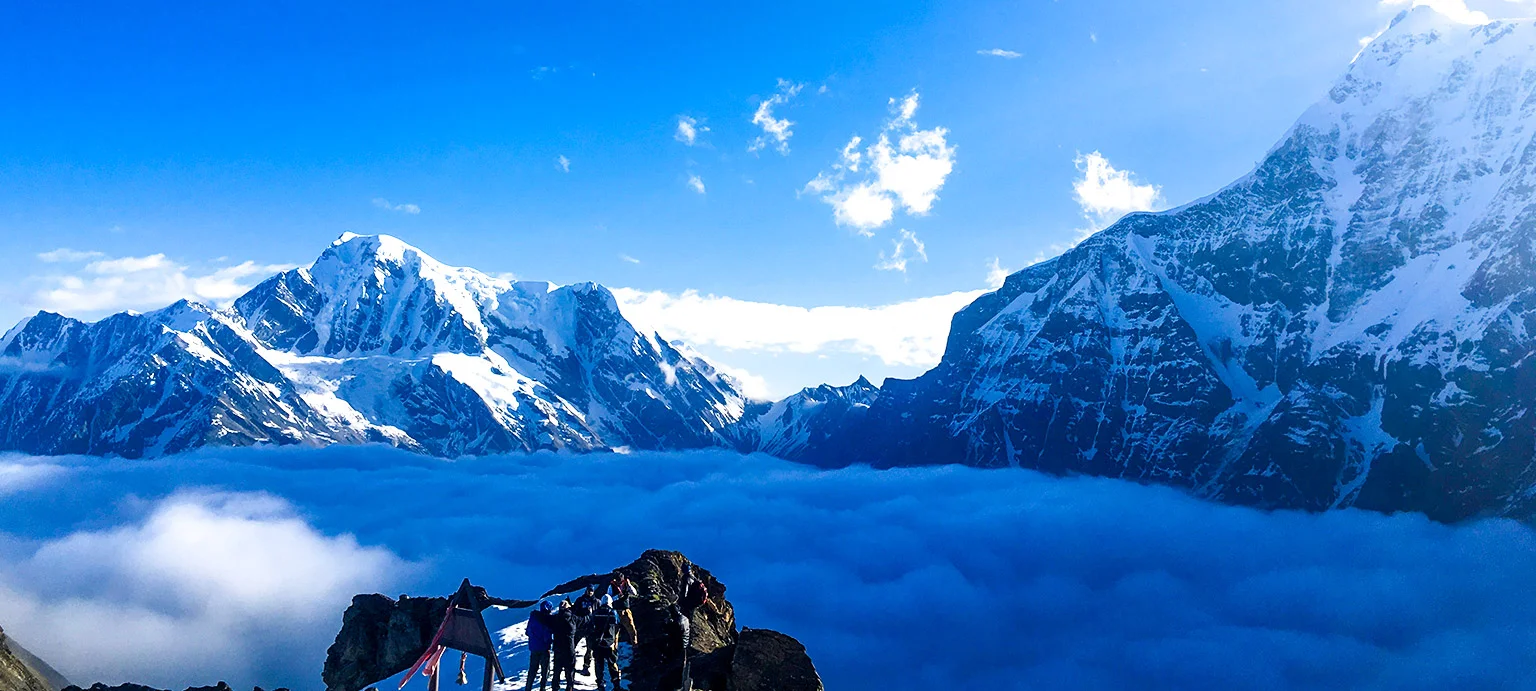
A Tough day as on Day four you have to climb to the Junargali Dhar (5,029 meters), the top offers a beautiful view of the Nanda Devi.
Explore the Roopkund lake surrounded by ancient skeletons.
Return to Pathar Nachauni via Bhagwabhasa
Camp at Patthar Nachauni for the night.
SHORT ITINERARY:
DAY 6: Trek from Bhagwabasa to Roopkund (15,756 feet), further to Junargali Top (16,156 feet)
Distance: 8 KM / Time: 7–8 Hours / Altitude: 15,756 ft (4,800 m) / Altitude (Junargali Top): 16,156 ft (4,925 m)
DETAILED ITINERARY:
To accommodate the cold weather, we will first have hot tea or coffee and then pack breakfast to leave for Roopkund. But the white clouds are covering the mountains in a matter of moments. Our goal for the day is to reach an altitude of 5,029m above sea level known as Junargali Dhar Top from 400m below. This lake is located at high altitudes. Legend has it that the lake contains the bones of people who inhabited the earth in ancient times, thus it is often referred to as the "Mystery Lake." These skeletons are visible when the ice thaws. If you are lucky, you can see these skeletons on the edge of the lake. The site you will be seeing will surely take your breath away when you stand on the top of Junargali and look towards the temple of Nanda Devi. This is because it is windy at the peak. However, you will also be filled with a sense of accomplishment standing at the top of this peak, that nothing else compares to.
Return once again to Pathar Nachauni by going through Bhagwabhasa. The descent will be more challenging because while climbing the trail was steep whereas descending. It gets more exciting so enjoy the journey, and relax your mind and body for your trip. You camp out and have your meal after a day of trek. Dinner and overnight stay in tents.
Trek down to Wan and visit the Latu Devta Temple, walk the trail surrounded by dense himalayan forest.
Reach Lohajung by dinner time and rest at the guest house, reminisce about the trek so far and prepare for the next day.
SHORT ITINERARY:
DAY 7: Trek from Pathar Nachauni to Lohajung via Bedni and Wan and back to Lohajung Distance: 15 KM / Time: 6–7 Hours / Altitude: 7,700 ft (2,347 m)
DETAILED ITINERARY:
As you trek in the lap of nature there are large trees, moving towards Lohajung. The villagers have organized a puja at the popular temple of Latu Devta in Wan village. You may go to the temple or have a rest over here. As you descend, a forest region will surround you. After that, go to the bank of the river Neel Ganga, and walk towards Wan village — a lovely little mountain village. Return to Lohajung in a cab. Stay overnight at the guesthouse after dinner.
As you reach Lohajung, dinner awaits and for the last time, you check in at a tourist guest house, contemplating the memories of this wonderful stretch of Himalaya. After several days of trekking on challenging routes, the guest house offers a relaxing and pleasant ambiance for you to retire. This is a good time to take a rest, meet and hear the experiences of others who have trekked, and relish the moments that made the experience worth the whole journey. The calm village, amidst hills, provides the necessary ambiance for you to take a rest and refresh yourself before the end of the trek. The last night at Lohajung also encourages you to soak in the sights and sounds of such a beautiful and tranquil area.
Drive to Kathgodam
Watch the mountains and the trees that you see on the first day, pass you by.
SHORT ITINERARY:
DAY 8: Drive from Lohajung Village to Kathgodam Railway Station Distance: 220 KM / Time: 9–10 Hours / Altitude: 1,870 ft (570 m)
DETAILED ITINERARY:
Upon completing the amazing views during the Roopkund trek, you will drive from Lohajung in the morning. There is a final stretch which is captivating and stress relieving to the place known as Kathgodam, which will allow you to view mountains and forests one more time. When you reach Kathgodam, you will reach the railway station between 6:30 pm to 7:00 pm. This ends your trek, and you board your train or move on with the cherished experience of the Himalayas.
Roopkund Trek Map

Trek Review Videos

Inclusions
Exclusions
1. Meals while on trek (Veg.).
2. All necessary entry fees and permits.
3. Accommodation:- Guest house / Camping during Trek.
4. Mountaineering qualified & professional trek Leader, guide, cook, and Support staff.
5. First aid medical kits, stretcher, and oxygen cylinder.
6. Trek equipment: Sleeping bag, mattress, tent, kitchen & dining tent, toilet tent, utensils, and crampon (if required)
7. Staff Insurance.
8. Porters/mules to carry central equipment.
1. Any kind of personal expenses.
2. Food during transit.
3. Mules or porters to carry personal luggage.
4. Insurance.
5. Transport (Non Ac)
6. Any kind of emergency evacuation charges
7. 5% GST
8.Any expense incurred or loss cost by reasons beyond our control such as bad weather, natural calamities (landslides, floods), flight delays/rescheduling/ cancellations, any accidents/medical evacuations, riots/strikes/war/pandemics etc.
9. Anything not specifically mentioned under the head.
What to carry
- Trekking shoes: A good pair of trekking shoes is essential for a comfortable and safe trek. Look for shoes that are sturdy, provide good ankle support, and have a good grip on different types of terrain.
- Backpack with rain cover (50-60 ltr): A backpack is necessary to carry all your gear. Make sure it's the right size for your trek, and comes with a rain cover to keep your belongings dry in case of rain.
- Thermals (upper and lower): Thermals are lightweight and comfortable base layers that help regulate your body temperature in cold weather. Bring both upper and lower thermals to keep warm.
- 3 T-shirts (advisable quick dry): Choose quick-drying T-shirts made from breathable and moisture-wicking materials. This will help keep you cool and dry during your trek.
- 2 trek pants: Choose lightweight and comfortable trek pants that are easy to move in and can dry quickly if wet.
- Jacket (-10 degrees): A warm jacket is essential for cold weather. Choose a jacket that is waterproof and windproof, and provides good insulation.
- Fleece or hood (2): Fleece jackets or hoodies are great mid-layer options to keep warm. Bring at least two, as they can also be used as an extra layer at night.
- Sunglasses (UV protected): Protect your eyes from the sun's harmful UV rays with sunglasses that are designed for outdoor activities.
- Sun cap: A sun cap or hat with a brim will protect your face and neck from the sun.
- Hand gloves: Bring a pair of lightweight gloves to keep your hands warm and protected from wind and sunburn.
- Woolen cap: A woolen cap will keep your head and ears warm at night or in cold weather.
- Socks (3 pairs min): Bring at least three pairs of good quality socks that are moisture-wicking and provide good cushioning and support for your feet.
- Headlamp: A headlamp will come in handy if you're hiking in low-light conditions or need to find your way in the dark.
- Trekking pole (if needed): Trekking poles can help reduce strain on your legs and provide additional support on steep terrain.
- Rain cover\poncho: A rain cover or poncho will keep you and your gear dry during unexpected rain showers.
- Day pack (if you plan to offload your bag): If you plan to offload your backpack during the trek, bring a smaller day pack to carry essentials like water, snacks, and a first aid kit.
- A toiletry kit: Bring a small kit with personal hygiene items, such as a toothbrush and toothpaste, wet wipes, hand sanitizer, and toilet paper.
- Lunchbox, cup, spoon: If you plan to bring your own food, bring a lunchbox, cup, and spoon to carry and eat your meals.
- 2 one-liter bottles: Staying hydrated is crucial, so bring at least two one-liter bottles to carry water.
- 2-3 plastic covers to keep your wet or used clothes: Plastic bags are useful for keeping wet or dirty clothes separate from the rest of your belongings. They can also be used to pack out any trash or waste you generate during the trek.
How to reach
Kathgodam station is among the major stations within the district, existed for a long time. It is connected to a variety of places, which are Lucknow, Delhi, and Howrah. Train tickets from Delhi to Kathgodam via train will cost you around the price of Rs. 150 for a sleeper second class ticket, and the price is Rs. 400 for the third sleeper ticket. It is crucial to reserve the tickets at minimum one month ahead because this type of ticket is always highly sought-after.
By Train :-
From Delhi go to The Ranikhet Express (5014) Dep. Delhi at 10:40pm and arrive Kathgodam at 5:55am (Overnight journey) and it’s the Uttar sampark kranti (5035) Dep. Delhi at 4:45pm. Arrival Kathgodam at 10:40 pm (6 hrs.40min.Journey)
From Dehardun Take from Dehardun the Doon Express (4120) Dep. Dehardun by 10:30 pm, arriving Kathgodam at 7:10 midnight (8hrs.journey)
By Bus :-
Regular buses operate departing from ISBT Delhi Anand Vihar station to Kathgodam. Buses heading to Nainital stop in Haldwani, which happens to be a twin city of Kathgodham (8 hours. Journey).
The majority of buses drop you off at Haldwani bus stop. From there, you must travel close to Kathgodham Railway Station which is only 4 km away.
Its Tata Sumo or similar vehicles will take you to Kathgodham Railway Station at 6:00am.
We suggest that you use only government buses to ISBT Anand Vihar. Private buses depart from outside ISBT , and they’re not trustworthy.
Fitness and preparation guide for Roopkund Trek
We recommend jogging as the best routine to get fit for a trek. It works on the same muscles that you use while trekking — your calves, glutes and hamstrings. It helps increase your stamina day by day. It is also an easy routine that does not require any equipment or tools.
Fitness target:
To do this trek comfortably, you must be able to cover 5 km in under 35 minutes. This is the minimum fitness required for this trek.
How to achieve this fitness?
- Start jogging at least 4 days a week
- If you cannot run 5 km immediately, start with 2 km and increase to 5 km over 2-3 weeks.
- Once you’re able to run 5 km, increase your pace day by day.
- Gradually increase your pace and bring it down to 5 km in less than 35 mins.
- You must be able to run 5 km in 35 mins consistently for at least 2 weeks before the trek.
This trek requires at least 6-8 weeks of preparation. The longer, the better. So plan your trek soon and start preparing.
FAQ
The Roopkund Trek is considered a moderate trek. It involves steep ascents, challenging terrain, and high-altitude conditions. The Roopkund trek requires a good fitness level and previous trekking experience. The trek can be slippery, especially near the higher altitudes, making it physically demanding for beginners.
The ideal months to do the Roopkund Trek are from May to June( pre monsoon) and September to October (post monsoon) During these months, the weather is generally clear and pleasant, with moderate temperatures. These periods avoid the monsoon and harsh winter, making the trek safer and more enjoyable.
The Roopkund Trek typically takes 7 to 9 days, depending on the itinerary. The Roopkund trek includes proper adaptation and rest days that will help you to adjust to the high altitudes. The trek involves several stops.
Roopkund Lake is situated at an altitude of approximately 5,029 meters (16,500 feet) above sea level. The trek itself reaches altitudes as high as 4,600 meters (15,091 feet), which makes it a high-altitude trek, requiring proper adjustment to the surroundings to avoid altitude sickness.
For the Roopkund Trek, you should carry essentials like trekking boots, warm clothing (jackets, thermals), a sleeping bag, a raincoat, a headlamp, and a first aid kit. It’s also important to pack water bottles, high-energy snacks, sunscreen, and personal identification for the journey.
Yes, a guide is highly recommended for the Roopkund Trek, especially for beginners. While the trek l is well-defined, the challenging terrain and high altitude can make navigation difficult. A guide from Himalayan Daredevils will ensure your safety, helps with acclimatization, and provides valuable insights into the region's history and culture.
The major highlights of the Roopkund Trek include the stunning alpine meadows of Bedni Bugyal and Ali Bugyal, amazing views of the Nanda Ghunti and Trishul peaks, and the mystical Roopkund Lake. The trek also features ancient human skeletons near the lake, offering a glimpse into the region's eerie past.
The main health concern for the Roopkund Trek is altitude sickness due to the trek’s high elevations. Symptoms include headaches, nausea, and dizziness. Proper acclimatization, hydration, and gradual ascent can help prevent this. Physical fitness is also important to avoid fatigue.
While the Roopkund Trek is challenging, a beginner with moderate fitness and prior trekking experience can attempt it. Beginners should prepare by training beforehand, focusing on endurance, strength, and stamina. Adequate guidance and acclimatization will be essential to complete the trek safely.
Roopkund Lake is known for the mysterious human skeletons found at its shore, scattered in and around the lake. The skeletons, believed to date back to the 9th century, have sparked theories about an ancient pilgrimage, a mass death event, or a natural disaster, making it a subject of intrigue. Still there are theories revolving around the mysterious skeletons and no strong evidence.
Cancellation policy
Life is unpredictable and we understand sometimes you have to cancel or change your trip dates and it is our endeavour to make it as easy possible for you. However, please understand we plan everything including guide fees, permits, accommodation and ration in advance. Therefore any cancellation means inconvenience and certain losses to the people involved in various stages of programme. Keeping that in mind, our cancellation charges are as below-
Cancellation prior to 30 days from start of the event: Get monetary refund with 15% of cancellation charges on trek fee.
Cancellation between 30 days and 15 days to the start of event: 50% on trek fee is non refundable and the remaining 50 % will be given as cash voucher which is valid for 1 year.
Cancellation less than 15 days to the start of event: No refund.
Please note cancellation will be only accepted by email.
Booking amount is non refundable
Note: The Himalayan Daredevils reserves the right to cancel a programme before departure in the event of logistical problems arriving due to natural calamities, strikes, wars on any other circumstances that makes the event inadvisable. In this case, 50% on trek fee is non refundable and the remaining 50 % will be given as cash voucher which is valid for 1 year.
Itinerary changes & trip delays:
We plan itineraries based on the information at the time of planning and in rare circumstances, there are subject to change. In the event that the itinerary is changes or delayed due to unforeseen circumstances such as bad weather conditions, transportation delays, government intervention, landslides etc. We will always aim to give you the best experience possible. However The Himalayan Daredevils are not be held responsible for the cost of delay or changes.
Why Choose Us
Our Best Performance
50,000+
Trekkers
PAN India Treks
250+
Treks
Professional
and Experienced Staff
Best
Grade Equipment
Well Organised
Trek Itineraries
Related Blogs
Read and get more about our treks
Exploring The Mysterious Skeleton Lake In Uttarakhand
Sar Pass Trek: Detailed Itinerary, Trekking Essentials & Best Time to Visit
Harkidun Trek: Detailed Itinerary, Trekking Essentials & Best Time to Visit
Rupin Pass trek : Detailed Itinerary, Trekking Essentials & Best Time to Visit
Bali Pass Trek: Detailed Itinerary, Trekking Essentials & Best Time to Visit
Ali Bedni Bugyal: Detailed Itinerary, Trekking Essentials & Best Time to Visit
Kedartal trek: Detailed Itinerary, Trekking Essentials & Best Time to Visit
Hampta Pass trek: Detailed Itinerary, Trekking Essentials & Best Time to Visit

Kashmir Great Lakes Trek – A High-Altitude Journey to Remember
Key Highlights of the Hampta Pass Trek You Shouldn’t Miss
How to Get Fit for the Hampta Pass Trek
Valley of Flowers Trek- What It Gives and What It Doesn’t
Roopkund Trek Best Time: Month-by-Month Weather, Snow & Trail Conditions
Roopkund Trek vs Khopra Ridge Trek: Difficulty, Best Time, Cost & Experience Compared
Affiliated and Recognised by


Download Our Apps