Starting From
11,270
9,800.00
Starting From
11,270
9,800.00
Starting From
11,270
9,800.00
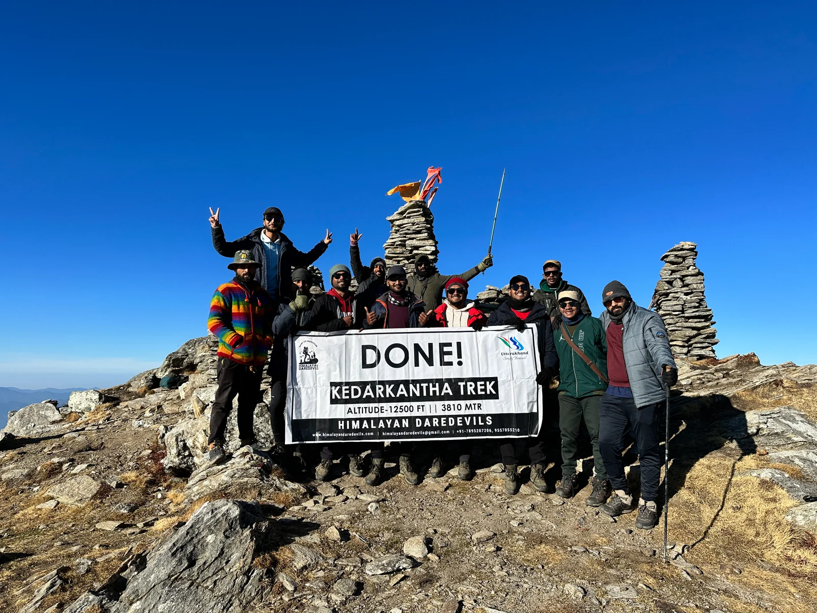
Pangarchulla Peak Trek (225+ Reviews)
Summit, Point to point | Scale a peak, Camping at the same location upon returning.
Dehradoon Railway Station
Jolly Grant Airport, which is 21 km away from Rishikesh
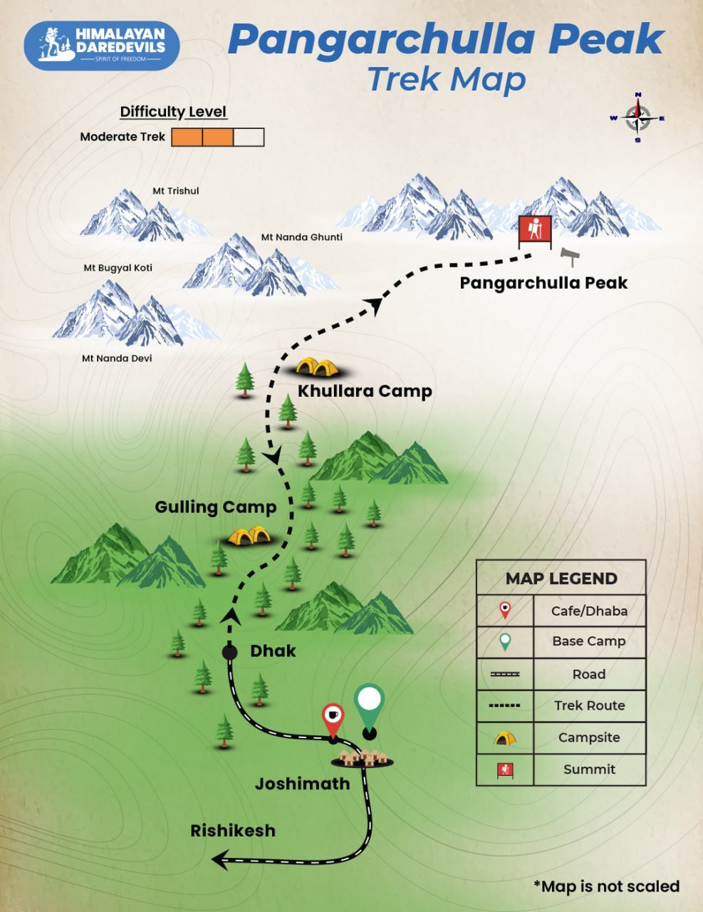
Joshimath
March | April
Joshimath to Joshimath
Meals while on trek & at Hotel/Guesthouse (Veg & Eggs)
Guesthouse / Camping tent
Uttarakhand
6 Days
Moderate
15100 Ft.
43 Km.
Overview of Pangarchulla Peak Trek
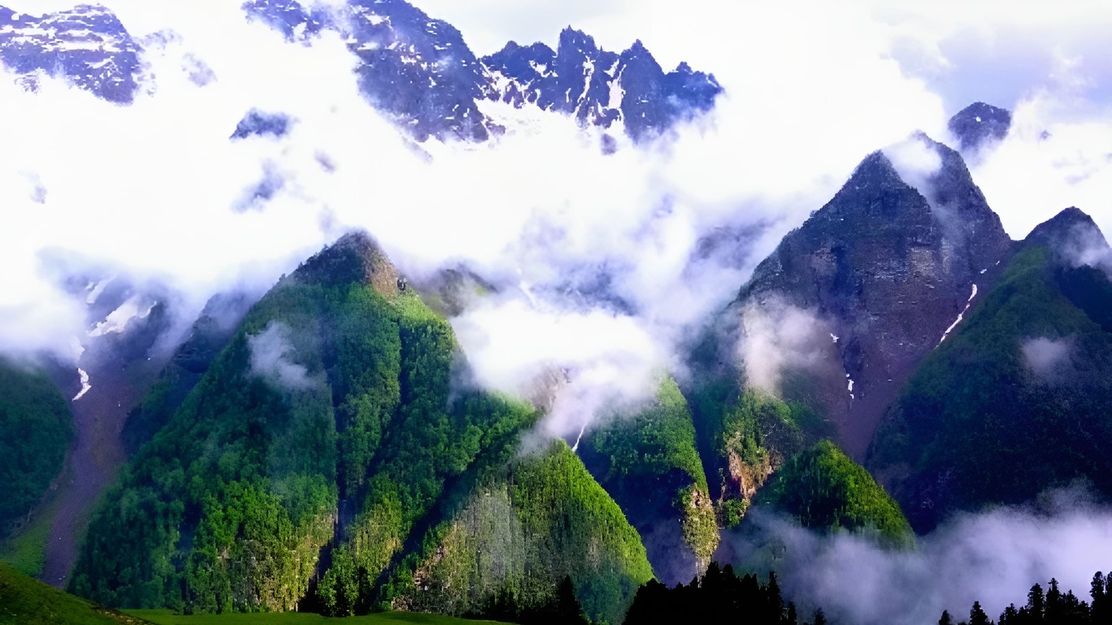
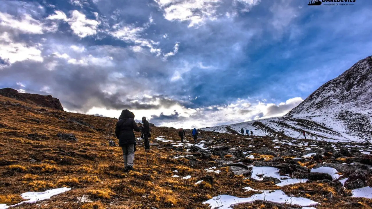
The Pangarchulla Peak Trek is one of the most thrilling and rewarding high-altitude summit treks in the Garhwal Himalayas of Uttarakhand, India. Rising to an impressive altitude of 15,096 feet (4,600 meters), this adventure offers breathtaking views of snow-capped Himalayan peaks, sweeping alpine meadows, and dense oak-rhododendron forests. From rugged mountain ridges to serene green valleys, every section of the trail delivers unmatched natural beauty.
This 6-day, 5-night Himalayan trek begins and ends at Dhak Village, located a short drive away from Joshimath, the main base town in the Chamoli district of Uttarakhand. Unlike heavily crowded trekking routes, the Pangarchulla trail remains relatively less explored, allowing trekkers to truly immerse themselves in peaceful surroundings and untouched landscapes. Here, you’ll experience the solitude, silence, and pristine wilderness that every mountain lover yearns for - away from tourist-heavy trails.
If you are searching for a trek that combines summit adventure, panoramic mountain views, and uncrowded Himalayan trails, the Pangarchulla Peak Trek is the perfect choice.
Pangachulla Peak Trek Highlights
The Pangarchulla Peak Trek is packed with unforgettable views, natural beauty and adventure. It has everything that the Himalayas have to offer bundled into a 6 day trek, making it an unforgettable getaway into the mountains. Here's a detailed look at the standout features of this spectacular journey:
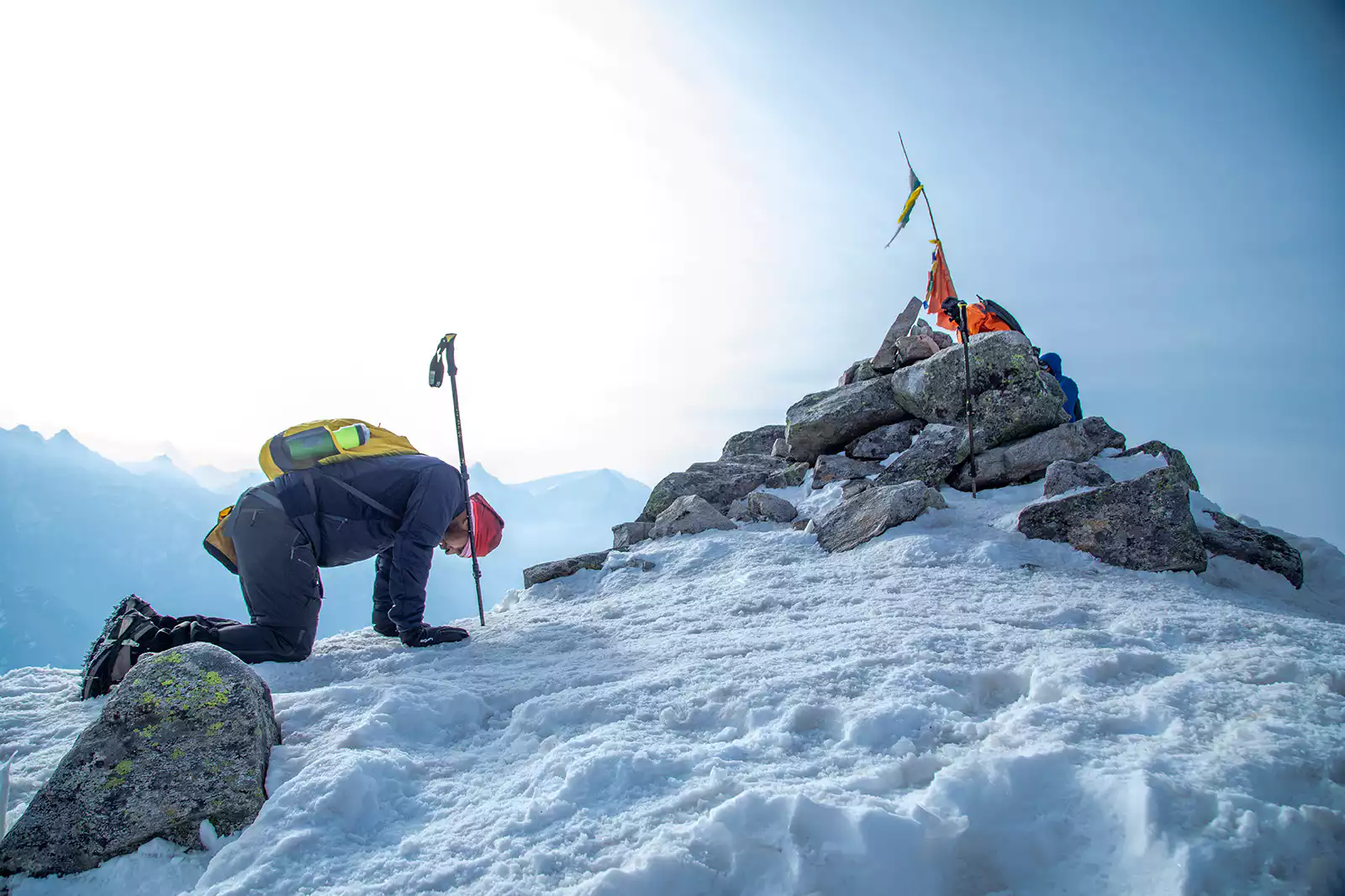
Summit a 15,096 ft Himalayan Peak
The thrill that comes with climbing a snow-capped peak is unmatched, at an altitude above 4,000 meters the landscape changes drastically. The vegetation is limited to nil, the trail becomes rugged and tough to trek on and the scenery is otherworldly. Climbing the Pangarchulla Peak is indeed challenging, it is not easy to climb the rocky terrain covered in thick snow, these difficulties make reaching the top even more rewarding.
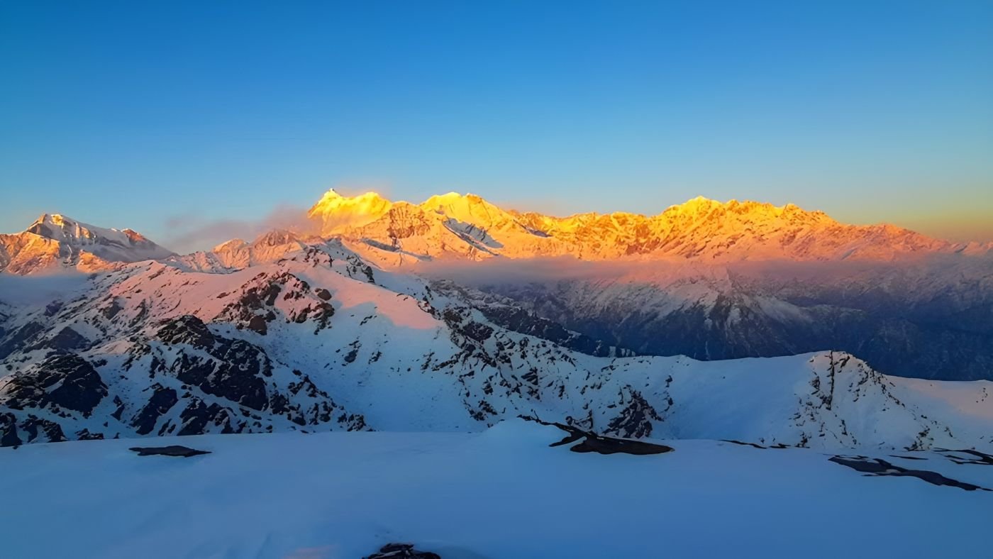
From the summit, you can see Nanda Devi, Trishul, Dronagiri, Kamet, Mana Peak, and the twin peaks of Hathi-Ghoda Parvat — a photographer’s dream and a moment of awe for every trekker.
Rich and Changing Landscapes
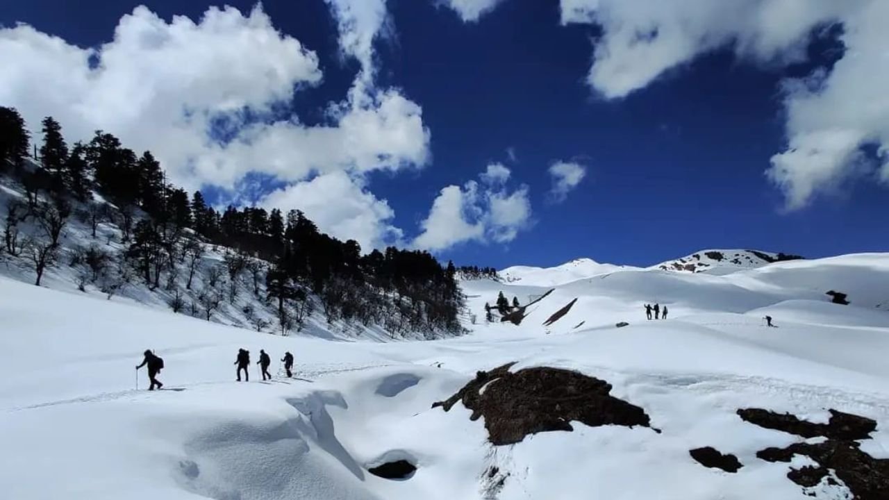
The Pangarchulla Peak Trek offers a diversity of landscape, taking you from one world to another, from green forests to grey rocky mountains covered in snow. The route takes you through:
Dense forests of oak, rhododendron, and maple
Traditional Himalayan villages
Wide alpine meadows (bugyals), especially near Khullara and Chitrakantha
Rocky ridgelines and snowy sections on summit day
The contrast between green valleys and snow-clad slopes makes this trek visually stunning and constantly engaging. There is never a dull moment on the trek and if you blink you may miss something.
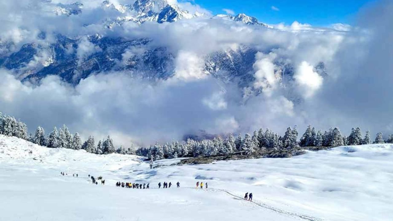
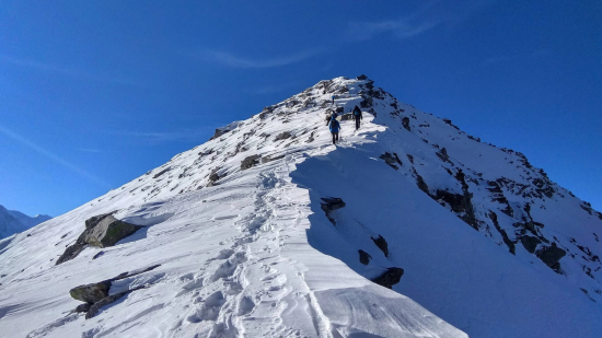
Snow Trekking Experience (in Spring/Winter)
In the spring when the rest of the country is dealing with the hot weather is the time when the trail leading to the Pangarchulla Trek is covered with thick snow. This gives the trekkers a true snow trekking experience making it one of the best spring treks in Himalayas. If you plan your trip right now you will be able to see crystal-clear views of Nanda Devi, Hathi-Ghoda, and Dronagiri looming in the background as you climb the Pangarchulla Peak.
To trek through the snow you must carry the specialised trekking gear so that you trek is safe and comfortable, the gear must include:
- Waterproof trekking boots
- Gaiters
- Microspikes or crampons
- Trekking poles
- UV-protection sunglasses
- Thermal base layers
- Insulated down jacket
- Headlamp with extra batteries
These are essential for safety, warmth, and grip during snow-covered sections of the Pangarchulla trek.
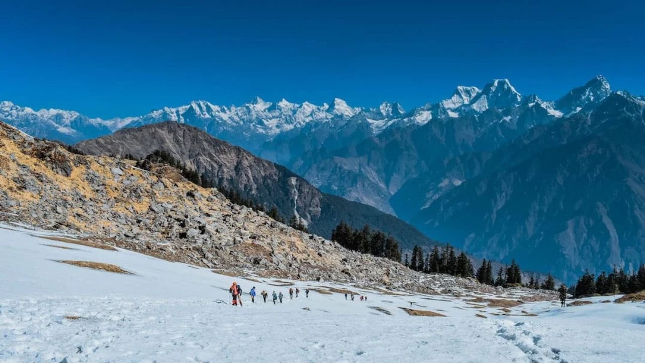
Panoramic Views of Mighty Himalayan Peaks
At an altitude of above 4,000 meters you will find yourself surrounded by the Himalayan giants. The snow capped peaks that look like far away wonderlands from below, look totally different when you see them eye to eye. The Pangarchulla Trek gives you the opportunity to first see the majestic himalayan peaks from a distance and then to slowly climb closer to them. From the summit, you can witness a stunning skyline featuring:
- Nanda Devi – 7,816 m (25,643 ft)
- Kamet – 7,756 m (25,446 ft)
- Dronagiri – 7,066 m (23,182 ft)
- Mana Peak – 7,272 m (23,858 ft)
- Hathi Parbat – 6,727 m (22,070 ft)
- Ghori Parbat – 6,708 m (22,000 ft)
- Neelkanth – 6,596 m (21,640 ft)
- Changabang – 6,864 m (22,520 ft)
This visual grandeur is a highlight of the trek and a major reason why Pangarchulla is among the best summit treks in Uttarakhand.
Best Time To Visit Pangarchulla Trek
Choosing the right time to visit the Pangarchulla Trek can help you with getting the most out of Trek. Each season packs different colors and experiences, it helps if you know what suits you the best:
Spring (April – Early May)
Temperature: 5°C to -5°C
Why Trek Now: Ideal for snow trekking, clear skies, and stable snow for summit attempts.
Description:
Spring is the most popular time to trek to the Pangarchulla Trek, the snow is still present in the upper reaches, offering a thrilling summit climb. You will see some crowd on the trek during this time. The days are sunny and the nights are cold, but the weather remains stable. It’s the perfect time for trekkers looking for adventure, alpine beauty, and dramatic snow landscapes.
Summer (Late May – June)
Temperature: 10°C to 2°C
Why Trek Now: Pleasant weather, melting snow, lush green meadows, and easier trails.
Description:
Most of the snow has melted by late May and the green carpet of the high-altitude alpine meadow is revealed. The trail is easy and safe to walk on as there are less chances of the path being slippery and muddy. This is a great time for those who want an easier summit experience without snow challenges. Expect pleasant weather and blooming landscapes, but views might be slightly hazy due to rising temperatures.
Monsoon (July – Mid-September) (Not Recommended)
Temperature: 12°C to 5°C
Why Avoid: Heavy rainfall, slippery trails, landslide risk, poor visibility.
Description:
The monsoon season brings a lot of challenges to the trekkers, the trail becomes slippery, there is a risk of landslides causing road blocks and the constant rain makes the starting of the trail covered in vegetation making it hard to find the trail. Cloud cover often blocks mountain views, and road connectivity can be disrupted due to landslides. Trekking during this time poses safety risks and reduced overall experience.
Autumn (Mid-September – November)
Temperature: 10°C to -2°C
Why Trek Now: Clear post-monsoon skies, dry trails, vibrant landscapes, perfect photography conditions.
Description:
Autumn is a stunning time for the Pangarchulla trek. The skies are crystal clear, offering uninterrupted views of the Himalayan giants. The landscapes turn golden with dry grass and crisp air. It’s a quieter season with fewer trekkers, making it ideal for those who prefer solitude and scenic beauty.
Winter (December – February) (Not Recommended)
Temperature: 0°C to -10°C
Why Avoid: Extreme cold, deep snow, blocked summit, and trail closures.
Description:
In winter, the Pangarchulla trail gets buried under heavy snow, making the summit climb extremely difficult or inaccessible. Harsh temperatures and closed routes make it unsuitable for most trekkers. While the snow scenery is beautiful, the trek is rarely operated during this time due to safety concerns.
Difficulty Level & Physical Preparation for Pangarchulla Trek
Trek Difficulty: Moderate to Difficult
The Pangarchulla Trek is graded as a moderate to difficult Himalayan trek, best suited for fit beginners or experienced trekkers. The majority of the trek is a moderate climb through the lush green forests and green alpine meadows, it is the summit day which is long, steep and physically demanding. The trek is especially difficult during the snow season (April-May), when the ascent involves trekking through ice,snow, and rocky ridgelines.
Here's what makes it a difficult high-altitude trek:
Steep and Long Summit Day
The summit day involves 8–12 hours of continuous trekking, covering a steep ascent and descent.
The final ridge to the summit is narrow, exposed, and physically exhausting, especially in snow.
Snow and Ice Terrain (April–May)
During spring, the trail is often covered in snow, requiring you to walk with microspikes or crampons.
Snow trekking demands more energy, reduces grip, and challenges your balance.
High Altitude (15,069 ft / 4,593 m)
Oxygen levels drop significantly at higher altitudes, making breathing harder.
Many trekkers experience altitude-related fatigue or mild AMS symptoms.
Mixed and Technical Terrain
The trail includes mud, rocks, snowfields, and steep ridges.
Some sections, especially near the summit, require careful footwork and stability.
Requires Strong Endurance
You must trek for multiple hours daily (6–8 hours on average), carrying your daypack.
Without preparation and stamina, fatigue can set in quickly.
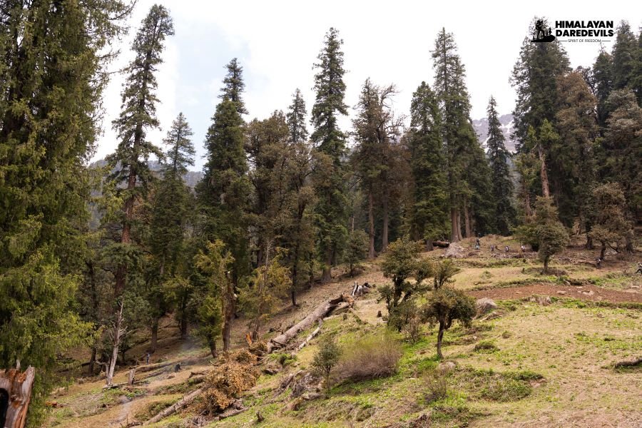
Pangarchulla Peak Trek Flora and Fauna: A Complete Guide for Nature Lovers
The Pangarchulla Peak Trek brings you closer to the flora and fauna of the Himalayan landscape. The trail hides a treasure of natural biodiversity, home to a wide range of flora and fauna. From lush oak forests to high-altitude meadows and rare Himalayan wildlife, this trek offers a unique chance to connect with nature.
Whether you're a wildlife photographer, birdwatcher, or just a curious traveler, exploring the biodiversity along this trail adds a magical dimension to your journey.
Flora on the Pangarchulla Peak Trek
The trail covers a wide range of altitudes—from 2,000 to over 4,500 meters—each zone with its own unique plant life.
Lower Altitude Forests (2,000 m – 3,000 m)
These forests form the heart of the trek’s early stages, from Dhak village to Khulara campsite.
Rhododendron (Buransh): Bright red flowers bloom in March–April. Also used to make juice and local medicine.
Banj Oak (Quercus leucotrichophora): Dominates the temperate belt, providing food and nesting grounds for birds.
Deodar (Cedrus deodara): Adds a mystical feel to the forest, known for its aromatic wood.
Pine and Maple Trees: Frequently spotted in the mixed forests.
High-Altitude Meadows and Alpine Shrubs (Above 3,000 m)
As you climb higher toward Pangarchulla Base Camp, the forest opens up into Bugyals (alpine meadows).
Brahma Kamal (Saussurea obvallata): A rare Himalayan flower, sacred in Uttarakhand. Found during late summer.
Juniper Shrubs: Hardy, fragrant, and adapted to cold, dry conditions.
Dwarf Rhododendrons and Wild Alpine Herbs: Found blooming during May–June.
Fauna on the Pangarchulla Peak Trek
The trek falls in the buffer zone of the Nanda Devi Biosphere Reserve, making it a hotspot for Himalayan wildlife. Sightings vary depending on season and silence, but patient trekkers are often rewarded.
Mammals You Might Spot
Himalayan Tahr: Seen in small groups on rocky slopes and open meadows.
Musk Deer: Extremely shy; may be spotted at dawn or dusk.
Himalayan Black Bear: Found in forested sections; very rare to see.
Leopard & Snow Leopard: Present but elusive; their presence is known through pugmarks and local reports.
Birds to Watch For
Birdlife is abundant, especially from March to June.
Himalayan Monal: The colorful state bird of Uttarakhand, often spotted in the higher forest sections.
Koklass and Cheer Pheasants: Often heard calling through the forests.
Himalayan Griffon Vultures: Soaring above the ridges.
Sunbirds, Warblers, Treepies, and Tits: Seen fluttering around the rhododendron trees.
Reptiles and Insects
Lizards and Garden Snakes: Found in the lower forests.
Butterflies and Bees: Especially common during spring when flowers are in full bloom.
Take your time on the trail. Stop. Listen. Observe. The flora and fauna of Pangarchulla will reward you with unforgettable moments — the flash of a Monal in the trees, the sway of blooming rhododendrons, or the glimpse of a tahr against a snowy backdrop.
Itinerary
Begin your scenic journey from Rishikesh to Joshimath, covering 286 km in 9–10 hours by taxi
Drive through Devprayag, Rudraprayag, Karnaprayag, and Chamoli with stunning Himalayan views
Reach Joshimath by evening and check into your hotel (twin/triple sharing)
Rest and acclimatize while enjoying the mountain town’s peaceful surroundings
Total distance – 286 km | Journey time – 9/10 hours | Mode – By taxi | Altitude – Joshimath: 6152 feet | Night stay – Hotel (twin/three share basis)
Shorter Itinerary:
Detailed Itinerary:
Himalayan Daredevils organizes transport from Haridwar Railway Station, departing around 6:00–7:00 am. The journey from Rishikesh to Joshimath is a scenic 9–10 hour drive through valleys, rivers, and snow-capped peaks. Starting from Rishikesh, a spiritual town on the Ganges, you travel via Devprayag, Srinagar, Rudraprayag, Karnaprayag, Chamoli, and finally reach Joshimath.
The route offers views of Nanda Devi, Trishul, and Dronagiri, and passes through villages reflecting Garhwal's culture. Joshimath, at 6152 feet, is the base for treks to Valley of Flowers, Hemkund Sahib, and Auli. Accommodation is arranged in hotels on a twin/triple share basis. While here, visit Narsingh Temple, Shankaracharya Cave, Kalpavriksha, or take a cable car to Auli. Notable en route is Devprayag, where Alaknanda and Bhagirathi rivers meet. The road continues along the Alaknanda through dramatic mountain terrain. Carry warm clothes, start early, and keep snacks handy. This journey offers stunning Himalayan views and cultural richness — a memorable start to your trek.
Drive from Joshimath to Dhak village (12 km) through winding roads with beautiful mountain views.
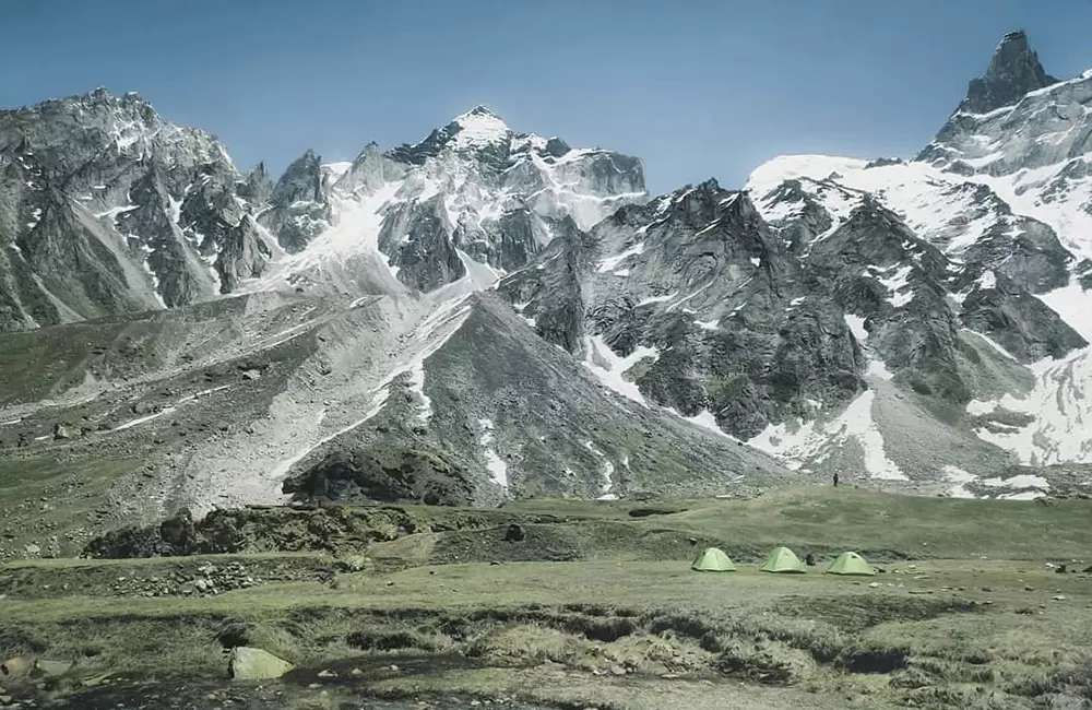
Begin the moderate trek from Dhak to Gulling Camp through forests, rocky paths, and scenic terrain.
Reach Gulling Camp by afternoon and settle into tents amidst serene Himalayan surroundings.
Spend the evening relaxing at camp under the stars, soaking in the peace of nature
Total distance – 17 km | Journey time – 4/5 hours | Mode – By taxi (12 km) + On foot (5 km) | Altitude – Gulling Camp: 9,832 feet | Night stay – Camp (twin share basis)
Shorter Itinerary:
Detailed Itinerary:
The day begins with a short 12 km drive from Joshimath to Dhak, taking around 30–45 minutes by taxi. The road, though narrow and winding in parts, offers beautiful views of snow-covered peaks and lush valleys. From Dhak, the trek to Gulling Camp begins — a moderate 5–8 km ascent depending on the trail, taking approximately 3–4 hours. The trek winds through dense forests, rocky terrain, and occasional stream crossings. The trail includes both ascending and descending sections, gradually leading you toward the campsite.
Throughout the route, you’ll witness the majestic Himalayan scenery with towering peaks, deep valleys, and rich greenery. Gulling Camp is nestled in a peaceful natural setting surrounded by tall trees and mountain views. The campsite provides basic facilities such as tents, sleeping bags, and freshly prepared meals by support staff. Spending the night here offers a quiet escape into the wilderness, with the chance to enjoy a warm campfire, starry skies, and the serene sounds of the forest. This day is a perfect introduction to the Himalayan trekking experience, combining a short drive with an immersive walk into nature.
Begin the trek from Gulling to Jangal Camp through alpine meadows, forests, and rocky trails.
Enjoy panoramic views of the Garhwal Himalayas and lush green valleys along the way.
The trail includes gradual ascents and some steep sections as you gain altitude.
Reach Jangal Camp by afternoon and relax amidst serene mountain surroundings.
Trek Distance – 5 km | Journey time – 4/5 hours | Mode – On foot | Altitude – Jangal Camp: 11,072 feet | Night stay – Camp (twin share basis)
Shorter Itinerary:
Detailed Itinerary:
The trek from Gulling Top to Khullara Camp covers approximately 7-8 km with an elevation gain of 300-400 meters. It’s a moderately difficult to challenging trek featuring steep ascents, rocky trails, and occasional loose gravel. The route descends initially before gradually ascending through alpine meadows, forests, and rugged terrain. Along the way, enjoy panoramic views of snow-capped Garhwal peaks, lush valleys, and glaciers. The final stretch involves a steep climb to Khullara Camp, situated at 13,989 feet, offering breathtaking mountain vistas. The trek takes about 4-6 hours, and starting early is recommended to reach camp before nightfall. This journey promises a memorable experience immersed in the pristine Himalayan wilderness.
Start early from Khullara Camp and trek to the Pangarchulla Peak summit, enjoying breathtaking panoramic views of the Himalayas.
The ascent involves steep and challenging terrain, requiring good fitness and acclimatization.
Spend some time at the summit soaking in the stunning vistas before descending back to Khullara Camp.
Rest and recover at the camp, surrounded by serene mountain beauty.
Trek Distance – Approx. 6 km | Journey time – 6-7 hours | Mode – On foot | Altitude – Pangarchulla Peak: 15,096 feet | Night stay – Camp (twin share basis)
Shorter Itinerary:
Detailed Itinerary:
The trek from Khullara Camp to Pangarchulla Peak summit is challenging but rewarding, covering about 5-6 km one way with an elevation gain of 700-800 meters. At 15,096 feet, the terrain includes steep rocky trails, scree slopes, and occasional snow patches. Trekkers should be fit, acclimatized, and experienced. The route starts with a gradual ascent through alpine meadows, becoming steeper and rockier near the summit, with some scrambling and exposed sections. Cairns mark the trail, so follow your guide carefully. The trek offers breathtaking views of Himalayan peaks like Nanda Devi, Trishul, Chaukhamba, and Kamet. The full trek (up and down) takes around 8-10 hours, so start early to return before dark. Overall, it’s an unforgettable Himalayan adventure with spectacular panoramic vistas.
Begin the descent from Khullara Camp to Dhak Roadhead, covering approximately 11 km in 5–6 hours.
The trail meanders through alpine meadows, dense forests, and rocky paths, offering glimpses of the surrounding Himalayan peaks.
Upon reaching Dhak Roadhead, board a taxi for the drive back to Joshimath, where you'll check into your hotel for the night.
Trek Distance: Approximately 11 km | Journey Time: 5–6 hours | Mode: On foot | Altitude: Khullara Camp: 11,122 ft; Dhak Roadhead: 6,867 ft | Night Stay: Hotel in Joshimath (twin share basis)
Shorter Itinerary:
Detailed Itinerary:
The trek from Khullara Camp to Dhak Roadhead spans approximately 11 km and takes about 5 to 6 hours. The trail descends through beautiful alpine meadows, forested areas, and rocky paths, with some gradual ascents and descents along the way. Trekkers will enjoy stunning views of Himalayan peaks, lush green valleys, and flowing streams or waterfalls, providing a peaceful and scenic end to the mountain adventure.
Upon reaching Dhak Roadhead, arrange a taxi for a 30 to 45-minute drive to Joshimath, covering around 11-12 km. This drive offers one last chance to admire the breathtaking mountain and valley landscapes before returning to civilization.
In Joshimath, you can check into your hotel for a comfortable night’s rest on a twin-sharing basis. Take some time to relax and reflect on your journey, or explore the town’s attractions and try some local Himalayan cuisine at nearby eateries.
Depart early from Joshimath and enjoy a scenic taxi drive back to Rishikesh, covering around 286 km in 9–10 hours.
Take in the majestic Himalayan views along the way and arrive in Rishikesh by evening, concluding your mountain journey.
Distance: Approx. 286 km | Journey time: 9–10 hours | Mode: By taxi | Night stay: N/A (end of trek)
Shorter Itinerary:
Detailed Itinerary:
On Day 6, you will begin your journey early in the morning, driving from Joshimath to Rishikesh by taxi. The approximately 286 km drive takes around 9 to 10 hours and offers stunning views of the Himalayan landscape as you pass through picturesque towns like Chamoli, Karnaprayag, Rudraprayag, Srinagar, and Devprayag. Along the way, you’ll witness the confluence of sacred rivers, lush valleys, and snow-capped peaks. The route is dotted with opportunities for short breaks to stretch, refresh, and enjoy the scenery. You will arrive in Rishikesh by late afternoon or early evening, marking the end of your mountain adventure. Here, you can check into your hotel or continue with your onward travel plans, carrying with you the memories of an unforgettable journey through the Garhwal Himalayas.
Pangarchulla Peak Trek Map
Inclusions
Exclusions
1. Meals while on trek (Veg. + Egg).
2. All necessary entry fees and permits.
3. Accommodation: - Guest house, Home stay, camping during Trek.
4. Mountaineering qualified & professional trek Leader, guide, cook and Support staff.
5. First aid medical kits, stretcher and oxygen cylinder.
6. Trek equipment: Sleeping bag, mattress, tent, kitchen & dining tent, toilet tent, utensils and crampon (if required)
7. Staff Insurance.
8. Porters/mules to carry central equipment.
1. Any kind of personal expenses.
2. Food during the transit.
3. Mules or porters to carry personal luggage.
4. Insurance.
5. Any kind of emergency evacuation charges
6. Anything not specifically mentioned under the head.
7. Transport (Non Ac)
8.Any expense incurred or loss cost by reasons beyond our control such as bad weather, natural calamities (landslides, floods), flight delays/rescheduling/ cancellations, any accidents/medical evacuations, riots/strikes/war/pandemics etc.
9. 5% GST
What to carry
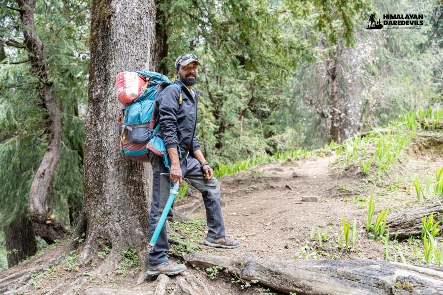
1.Trekking shoes: A good pair of trekking shoes is essential for a comfortable and safe trek. Look for shoes that are sturdy, provide good ankle support, and have a good grip on different types of terrain.
2. Backpack with rain cover (50-60): A backpack is necessary to carry all your gear. Make sure it's the right size for your trek, and comes with a rain cover to keep your belongings dry in case of rain.
3. Thermals (upper and lower): Thermals are lightweight and comfortable base layers that help regulate your body temperature in cold weather. Bring both upper and lower thermals to keep warm.
4. 3 T-shirts (advisable quick dry): Choose quick-drying T-shirts made from breathable and moisture-wicking materials. This will help keep you cool and dry during your trek.
5. 2 trek pants: Choose lightweight and comfortable trek pants that are easy to move in and can dry quickly if wet.
6. Jacket (-10 degree): A warm jacket is essential for cold weather. Choose a jacket that is waterproof and windproof, and provides good insulation.
7. Fleece or hood (2): Fleece jackets or hoodies are great mid-layer options to keep warm. Bring at least two, as they can also be used as an extra layer at night.
8. Sunglasses (UV protected): Protect your eyes from the sun's harmful UV rays with sunglasses that are designed for outdoor activities.
9. Sun cap: A sun cap or hat with a brim will protect your face and neck from the sun.
10. Hand gloves: Bring a pair of lightweight gloves to keep your hands warm and protected from wind and sunburn.
11. Woolen cap: A woolen cap will keep your head and ears warm at night or in cold weather.
12. Socks (3 pairs min): Bring at least three pairs of good quality socks that are moisture-wicking and provide good cushioning and support for your feet.
13. Headlamp: A headlamp will come in handy if you're hiking in low-light conditions or need to find your way in the dark.
14. Trekking pole (if needed): Trekking poles can help reduce strain on your legs and provide additional support on steep terrain.
15. Rain cover / poncho: A rain cover or poncho will keep you and your gear dry during unexpected rain showers.
16. Day pack (if you plan to offload your bag): If you plan to offload your backpack during the trek, bring a smaller day pack to carry essentials like water, snacks, and a first aid kit.
17. A toiletry kit: Bring a small kit with personal hygiene items, such as a toothbrush and toothpaste, wet wipes, hand sanitizer, and toilet paper.
18. Lunchbox, cup, spoon: If you plan to bring your own food, bring a lunchbox, cup, and spoon to carry and eat your meals.
19. 2 one liter bottles: Staying hydrated is crucial, so bring at least two one-liter bottles to carry water.
20. 2-3 plastic covers to keep your wet or used clothes: Plastic bags are useful for keeping wet or dirty clothes separate from the rest of your belongings. They can also be used to pack out any trash or waste you generate during the trek.
How to reach
Reaching Joshimath:
By Train:
From Delhi:
Board the Nanda Devi Express (12205) from Hazrat Nizamuddin at 11:50 PM, arriving at Haridwar around 4:00 AM the next morning.
From Haridwar, hire a shared/private taxi or take a bus to Joshimath (approx. 270 km, 9–10 hours drive via Rishikesh).
From Dehradun:
Board Dehradun Express (19020) from Mumbai, or any train reaching Dehradun by morning.
From Dehradun, take a taxi or bus to Joshimath via Rishikesh (approx. 300 km, 10–11 hours).
By Bus:
From Delhi (ISBT Kashmere Gate):
Overnight Volvo/Deluxe buses are available to Rishikesh (7–8 hours).
From Rishikesh, take a shared/private taxi or local bus to Joshimath (approx. 9–10 hours).
From Haridwar/Rishikesh:
Frequent shared cabs and GMVN buses leave early morning for Joshimath.
It is advisable to start by 6:00–7:00 AM to reach Joshimath before nightfall.
From Rishikesh to Joshimath:
Distance: Approx. 270 km
Travel Time: 9–10 hours
Route: Rishikesh → Devprayag → Srinagar → Rudraprayag → Karnaprayag → Chamoli → Joshimath
The drive offers beautiful views of river confluences, forested valleys, and Himalayan villages.
Additional Notes:
Roads are usually open year-round, but monsoon and winter may cause occasional closures due to landslides or snow.
It is strongly recommended to arrive in Rishikesh/Haridwar a day before the trek start date.
Private taxis are more flexible and comfortable, especially for groups.
Joshimath has basic ATMs, small markets, and accommodations for trekkers to acclimatize before starting the trek.
Fitness and preparation guide for Pangarchulla Peak Trek
1. Cardiovascular Endurance: Build stamina for long trekking days and high altitudes.
Exercises: Jogging, brisk walking (5–7 km daily), cycling, swimming
Frequency: 5 days/week
Goal: Sustain 45 minutes of continuous cardio
2. Leg Strength: Strengthen legs for steep ascents and descents.
Exercises: Squats, lunges, step-ups (with backpack), wall sits
Reps: 3 sets of 15–20
Focus: Thighs, hamstrings, calves
3. Core Stability: Support balance and backpack load.
Exercises: Planks, mountain climbers, leg raises, Russian twists
Reps: 3 sets of 30–60 seconds each
4. Upper Body Strength: Improve posture and help carry the backpack comfortably.
Exercises: Push-ups, shoulder presses, dumbbell rows
Reps: 3 sets of 10–12
5. Flexibility and Mobility: Prevent injury and support recovery.
Exercises: Yoga, dynamic stretches, hamstring and quad stretches
Frequency: Daily, especially after workouts
Train consistently for 4–6 weeks, gradually increasing intensity.
Pangarchulla is not for absolute beginners, but if you're fit and have done one or two Himalayan treks before, it’s a rewarding challenge. With proper training and mindset, the difficulty becomes part of the thrill.
FAQ
Iconic Himalayan peaks like the Nanda Devi, Dronagiri, Hathi Parbat, Ghodi Parbat, Chaukhamba I,II,III and IV, Neelkanth, Kamet and Mana Peak are visible to the trekkers from the summit of the Pangarchulla.
The Spring season (April to June) and the Post-monsoon season (September to November) are the best time to do the Pangarchulla Trek. During these months, trekkers can enjoy clear views of the surrounding peaks with vibrant wildflowers and blooming Rhododendrons covering the trail giving you the best experience of trekking in India.
The Pangarchulla Trek is considered moderately challenging. It features steep ascents and descents, along with a variety of terrains, including snow and ice. Anyone with basic fitness and some trekking experience can complete the trek comfortably.
The Pangarchulla Peak stands at above sea level and is the highest point of the trek.
Yes, It is possible to trek the Pangarchulla Trek solo, but it is recommended to go with a group or hire a guide. The Himalayas are unpredictable — weather and terrain conditions can change in the blink of an eye, making trekking difficult. Hiring a guide helps ensure safety and provides valuable support throughout the journey.
The mobile signal availability throughout the Pangarchulla Trek is patchy. You will find mobile signals at Joshimath (starting point of the trek) and on the route to the first camp at Guling, beyond this the mobile network remains weak and unreliable.
The highlights of the Pangarchulla Trek include a summit climb to 15,069 ft with breathtaking views of Nanda Devi and Dronagiri, diverse terrain featuring snowfields, forests, and alpine meadows, and the best trekking season in April–May. This moderate to challenging trek is ideal for those seeking an adventurous step beyond beginner trails.
To reach Pangarchulla Peak, first travel to Joshimath. Joshimath is about 270 km from Dehradun (nearest airport) and 230 km from Rishikesh (nearest railway station). From Joshimath, the trek to Pangarchulla begins. From Joshimath you will have to drive to the village of Dhak, which is the base camp of the trek.
The Pangarchulla trek takes you to an impressive height of 15,069 feet (4,590 meters). This trek is in the Chamoli district in the Garhwal Himalayas of Uttarakhand and offers exciting Himalayan terrains and panoramic views of the high Himalayan peaks.
43 kilometers is the total distance of the Pangarchulla Peak Trek, which typically takes around 6 days to complete. The trek begins from Dhak village in the Chamoli district of Uttarakhand and passes through diverse and stunning Himalayan landscapes. The first two days involve shorter, easier hikes, while the next three days require trekking for more than 8 hours each day. Summit day is the most challenging, with about 12 hours of trekking in total.
Cancellation policy
Life is unpredictable and we understand sometimes you have to cancel or change your trip dates and it is our endeavour to make it as easy possible for you. However, please understand we plan everything including guide fees, permits, accommodation and ration in advance. Therefore any cancellation means inconvenience and certain losses to the people involved in various stages of programme. Keeping that in mind, our cancellation charges are as below-
Cancellation prior to 30 days from start of the event: Get monetary refund with 15% of cancellation charges on trek fee.
Cancellation between 30 days and 15 days to the start of event: 50% on trek fee is non refundable and the remaining 50 % will be given as cash voucher which is valid for 1 year.
Cancellation less than 15 days to the start of event: No refund.
Please note cancellation will be only accepted by email.
Booking amount is non refundable
Note: The Himalayan Daredevils reserves the right to cancel a programme before departure in the event of logistical problems arriving due to natural calamities, strikes, wars on any other circumstances that makes the event inadvisable. In this case, 50% on trek fee is non refundable and the remaining 50 % will be given as cash voucher which is valid for 1 year.
Itinerary changes & trip delays:
We plan itineraries based on the information at the time of planning and in rare circumstances, there are subject to change. In the event that the itinerary is changes or delayed due to unforeseen circumstances such as bad weather conditions, transportation delays, government intervention, landslides etc. We will always aim to give you the best experience possible. However The Himalayan Daredevils are not be held responsible for the cost of delay or changes.
Why Choose Us
Our Best Performance
50,000+
Trekkers
PAN India Treks
250+
Treks
Professional
and Experienced Staff
Best
Grade Equipment
Well Organised
Trek Itineraries
Related Blogs
Read and get more about our treks
Best Time for Ali Bedni Bugyal Trek: Season-Wise Guide for Trekkers
Top 10 Reasons to Choose Buran Ghati Trek This Season
Which is Better: Pangarchulla Peak Trek or Kuari Pass Trek?
Pangarchulla Trek Best Time: Month-Wise Weather, Snow & Summit Conditions
Garhwal Himalayas Travel Guide – Best Places, Trekking & Char Dham Yatra
Dhak Village, Uttarakhand – Complete Travel Guide (Kuari Pass Base Village)
Affiliated and Recognised by


Download Our Apps